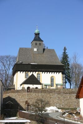
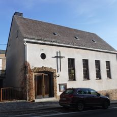
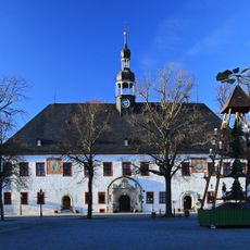
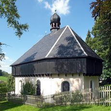
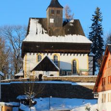
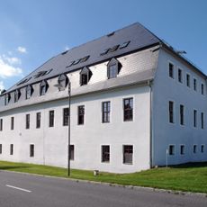
Wehrgangkirche Großrückerswalde, Fortified church in Großrückerswalde, Germany
Wehrgangkirche Großrückerswalde is a fortified church in the Ore Mountains with thick defensive walls and a distinctive ridge roof topped by a turret. The interior contains three gallery levels that rise within the solid stone structure.
The church was built in the 15th century and rebuilt after it was damaged during the Hussite Wars. It remains one of only a few fortified churches still standing in the area.
The church's name references the Wehrgang, a defensive walkway that once served protective purposes for the community. This link to defense remains visible in how the building looks today.
The site is best explored on foot as it sits in a small village setting. Check opening times in advance since the church primarily serves as an active place of worship.
A painting from the 16th century shows the church during a plague outbreak and offers a rare view of what the village looked like at that time. This historical artwork remains visible inside.
Location: Großrückerswalde
GPS coordinates: 50.63065,13.12014
Latest update: December 14, 2025 16:43
Dreibrüderhöhe
2.9 km
Museum sächsisch-böhmisches Erzgebirge
3.3 km
Jagdsäule (Marienberg)
3 km
Dreibrüderhöhe Observation Tower
2.9 km
Mauersberger-Museum
3.4 km
Methodistenkirche Marienberg
3.8 km
Kirche mit Ausstattung, Einfriedungsmauer des Kirchhofs, sieben Grabmale an der südlichen Kirchenwand und Denkmal für die Gefallenen des Ersten Weltkrieges - Sachgesamtheit Kirchberg 6
10 m
Royal Saxon milestone Poststraße Marienberg
3.5 km
Polish-Saxon Post Milestones in Marienberg
3.7 km
Herzog Heinrich Denkmal
3.8 km
Preßnitztalmuseum
3.6 km
Friedhofslinde
25 m
Anton-Günther-Stein Schindelbach
2.7 km
Polish-Saxon Post Milestones in Marienberg
3.2 km
Rathaus Marienberg
3.7 km
Ehem. Hotel in geschlossener Bebauung Markt 18
3.7 km
Kirche und Gruft - Sachgesamtheit An der Kapelle -
3.2 km
Kirche Mauersberg
3.5 km
Gerichtsgebäude (Nr. 31) mit angebautem Nebengebäude (Nr. 33) Zschopauer Straße 31; 33
3.7 km
Kirche mit Ausstattung, Einfriedungsmauer des Kirchhofs, neun Grabmale an der südlichen Kirchenwand und Denkmal für die Gefallenen des Ersten Weltkrieges - Einzeldenkmale Kirchberg 6
10 m
Wohnhaus in Ecklage und in geschlossener Bebauung Markt 17
3.7 km
Wohnhaus in Ecklage und in halboffener Bebauung Zschopauer Straße 21
3.8 km
Wohnhaus Bergstraße 40
3.1 km
Herrenhaus Rückerswalde
851 m
Wohnhaus in geschlossener Bebauung Zschopauer Straße 19
3.8 km
Wohnhaus (mit Apotheke) in Ecklage und in geschlossener Bebauung Markt 16
3.7 km
Wohnhaus in geschlossener Bebauung Markt 15
3.7 km
Wohnhaus in Ecklage und in geschlossener Bebauung und Mauer im Hof Markt 14
3.7 kmVisited this place? Tap the stars to rate it and share your experience / photos with the community! Try now! You can cancel it anytime.
Discover hidden gems everywhere you go!
From secret cafés to breathtaking viewpoints, skip the crowded tourist spots and find places that match your style. Our app makes it easy with voice search, smart filtering, route optimization, and insider tips from travelers worldwide. Download now for the complete mobile experience.
A unique approach to discovering new places❞
— Le Figaro
All the places worth exploring❞
— France Info
A tailor-made excursion in just a few clicks❞
— 20 Minutes