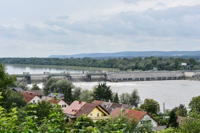
Egglfing-Obernberg Hydropower Plant, Run-of-river power station in Pocking, Germany.
The Egglfing-Obernberg Hydropower Plant stretches 255 meters across the Inn River, featuring six Kaplan turbines that generate electricity for Bavaria and Upper Austria.
Construction of the power plant began in July 1941 to supply energy to an aluminum smelter, with the final turbine installation completed in September 1950.
The facility represents a joint German-Austrian engineering achievement, operating on the Inn River that forms the natural border between the two countries.
The power station generates 485 million kilowatt-hours annually through its 84-megawatt capacity system, supporting regional energy needs in both countries.
The power plant creates a 12.7-kilometer reservoir recognized as part of the Ramsar wetland site Unterer Inn, supporting water management and wildlife habitats.
Inception: 1941
Length: 255 m
Website: http://www.verbund.com/pp/de/laufkraftwerk/egglfing-obernberg
Website: http://verbund.com/pp/de/laufkraftwerk/egglfing-obernberg
GPS coordinates: 48.31853,13.31998
Latest update: March 13, 2025 12:17
Burg Obernberg
1.1 km
Kath. Pfarrkirche und Friedhof Obernberg am Inn
1.2 km
Filialkirche hl. Nikolaus, Kulturhaus, Obernberg am Inn
866 m
St. Michael
1.2 km
Brunnen, Obernberg am Inn
1.2 km
Heimathaus Obernberg am Inn
1.3 km
Rathaustor, Obernberg am Inn
1.2 km
Bürgerhaus, Johann Peham's Schiffmeisterhaus samt 2 Wirtschaftsflügeln
981 m
Ledererhaus
1.5 km
Bürgerhaus, Pallhammersche Behausung, ehem. auch Glaserhaus
1.2 km
Modler'sche Behausung, Obernberg am Inn
1.2 km
Walterische Behausung, Apotheke zur hl. Jungfrau, Obernberg am Inn
1.2 km
Oberdorf'sche Behausung, Wörndlehaus, Obernberg am Inn
1.2 km
Pfarrhof
1.1 km
Ehem. Gasthof Bayerischer Hof, heute Rathaus
1.2 km
Tabernakelpfeiler, Kopfstätte
691 m
Wappenstein der ehem. Springer'schen Behausung
1.3 km
Bürgerhaus
1.2 km
Wohnhaus, ehem. Kolpinghaus
1.2 km
Bürgerhaus
1.3 km
Ehem. Schatzl'sche Behausung (östlicher Teil)
1.1 km
Gasthaus Marktplatz 8, Obernberg am Inn
1.1 km
Ehem. Mauthaus
955 m
Bürgerhaus, Weilhartische Behausung, ehem. auch Pflieglhaus
1.1 km
Ufergasse 5
1 km
Ehem. Schatzl'sche Behausung (westlicher Teil)
1 km
Bürgerhaus, sog. Dutzische Behausung
1.2 km
Ufertor
989 mReviews
Visited this place? Tap the stars to rate it and share your experience / photos with the community! Try now! You can cancel it anytime.
Discover hidden gems everywhere you go!
From secret cafés to breathtaking viewpoints, skip the crowded tourist spots and find places that match your style. Our app makes it easy with voice search, smart filtering, route optimization, and insider tips from travelers worldwide. Download now for the complete mobile experience.
A unique approach to discovering new places❞
— Le Figaro
All the places worth exploring❞
— France Info
A tailor-made excursion in just a few clicks❞
— 20 Minutes