Hürnigs Kopf, hill in Germany
Location: Rhineland-Palatinate
GPS coordinates: 50.50554,6.89797
Latest update: November 20, 2025 00:39
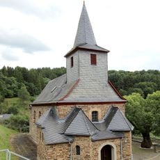
St. Martin
1.9 km
Burghaus Burgsahr
992 m
Hohe Nück
1.8 km
Wayside cross
1.2 km
Wayside shrine
1.5 km
Work of art, sculpture
1.5 km
Scenic viewpoint
805 m
Scenic viewpoint
1.3 km
Scenic viewpoint
1.8 km
Scenic viewpoint
1.5 km
Gretel Stollen
1.1 km
Den Toten zum Gedenken
1.9 km
Wayside cross
2 km
Wayside shrine
1.3 km
Das Zinkerz-Bergwerk Hüringskopf 1927-1939
1.1 km
Wayside cross
2 km
Förderkarren
1.1 km
HL Georg
1 km
Wanderer grüß den Herrn
271 m
Wayside shrine
1.1 km
Christianity, Catholic church building, wayside cross
2.2 km
Memorial stone, memorial
1.4 km
Wayside cross
1.4 km
Wegkreuz
1.4 km
War memorial, memorial
1.1 km
Catholic church building, wayside shrine, Christianity
1.4 km
Catholic church building, wayside shrine, Christianity
1.4 km
Catholic church building, wayside shrine, Christianity
2 kmReviews
Visited this place? Tap the stars to rate it and share your experience / photos with the community! Try now! You can cancel it anytime.
Discover hidden gems everywhere you go!
From secret cafés to breathtaking viewpoints, skip the crowded tourist spots and find places that match your style. Our app makes it easy with voice search, smart filtering, route optimization, and insider tips from travelers worldwide. Download now for the complete mobile experience.

A unique approach to discovering new places❞
— Le Figaro
All the places worth exploring❞
— France Info
A tailor-made excursion in just a few clicks❞
— 20 Minutes