
, an der Straße, Ende 19. Jahrhundert
Location: Fürstenzell
Address: Untersimbach 1
GPS coordinates: 48.49620,13.35638
Latest update: November 15, 2025 23:29
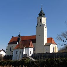
St. Michael
1.9 km
Kleine Kapelle
1.2 km
Kornspeicher Dobl 1 in Neuburg am Inn
1.1 km
Nebengebäude Oderer 1 in Fürstenzell
1.7 km
Vierseithof
483 m
Sägmühle
2 km
Zugehöriger geständerter Traidkasten mit Steilsatteldach
1.6 km
Friedhofskapelle Kirchenstraße 17 in Fürstenzell
1.9 km
Stall Untersimbach 3 in Fürstenzell
499 m
Tenne Untersimbach 3 in Fürstenzell
473 m
Einfirsthof
1.3 km
Vierseithof
592 m
Zugehöriger Südflügel
1.9 km
Bauernhaus eines Vierseithofes
1.7 km
Cultural heritage D-2-7546-0080 in Fürstenzell
1.9 km
Wohnhaus eines Vierseithofes
767 m
Vierseithof
1.1 km
Mittertennbau
1.3 km
Hauptgebäude der Aumühle
2 km
Vierseithof
984 m
Wohnhaus eines Vierseithofes
1.9 km
Wohnhaus eines Vierseithofes
1.6 km
Remise Dobl 1 in Neuburg am Inn
1.1 km
Zugehöriger Traidkasten
1.9 km
Scenic viewpoint
1.8 km
Wayside cross
1.8 km
Wayside cross
1.9 km
Wayside cross
1.9 kmReviews
Visited this place? Tap the stars to rate it and share your experience / photos with the community! Try now! You can cancel it anytime.
Discover hidden gems everywhere you go!
From secret cafés to breathtaking viewpoints, skip the crowded tourist spots and find places that match your style. Our app makes it easy with voice search, smart filtering, route optimization, and insider tips from travelers worldwide. Download now for the complete mobile experience.

A unique approach to discovering new places❞
— Le Figaro
All the places worth exploring❞
— France Info
A tailor-made excursion in just a few clicks❞
— 20 Minutes