Bettlerpfad, Hiking trail in Black Forest, Germany
The Bettlerpfad is a hiking trail in the Black Forest, running from Merzhausen near Freiburg to Badenweiler through forests, meadows, and several small villages. The trail is divided into sections with varying terrain and changes in elevation along the way.
The name Bettlerpfad, meaning Beggar's Path, comes from the Middle Ages, when traveling poor used this route to move between settlements in the Markgraflerland area. The path follows old connecting routes that crossed this region long before modern trail development.
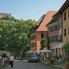
Along the way, small Black Forest villages offer local inns and traditional farmhouses built in wood and stone. The steady rhythm of forest and open fields reflects how people in this region have worked the land for generations.
Yellow diamond markers guide hikers along the route and help with orientation, as some sections have no clear signs between path junctions. Water and snacks are worth carrying since some stretches between villages have no services.
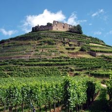
The trail passes through the Hexental valley and the Norsinger Grund, two narrow valleys from which you can look out toward both the Rhine Valley and deep into the Black Forest. These vantage points are especially worth pausing at in the evening, when the light changes angle.
The community of curious travelers
AroundUs brings together thousands of curated places, local tips, and hidden gems, enriched daily by 60,000 contributors worldwide.