Castrum Branodunum, Roman fort site in Norfolk, England
Castrum Branodunum is a Roman fort in Norfolk built as a rectangular fortified structure with walls originally about 3 meters wide and rounded corners fitted with internal turrets. The remains sit beside the A149 road and are accessible along the Norfolk Coast Path.
The fort was built around 230 AD as part of a defensive network protecting Britain's coast from maritime raiders across the North Sea. It served as a crucial military post during Roman rule in the region.
The site reveals aspects of daily military and civilian life through discovered objects like cavalry gear, coins, and pottery that tell stories of people who lived here. These artifacts show how Roman soldiers and local communities coexisted at this coastal outpost.
The site is freely accessible and easily located, with informative National Trust signs explaining the fort's layout and design. Its position beside the A149 road and the Norfolk Coast Path makes it straightforward to visit as part of a coastal walk.
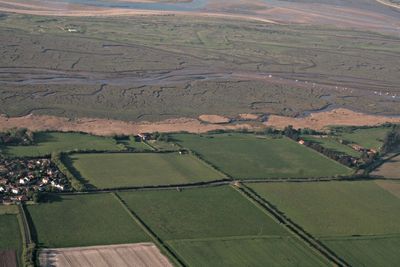
The fort's northern wall originally stood directly on the seashore serving as a harbor for vessels. Coastal erosion and land changes have since moved the remains inland about 1 kilometer, now surrounded by salt marshes.
Location: Norfolk
Part of: Saxon Shore
GPS coordinates: 52.96390,0.65190
Latest update: December 10, 2025 16:28
Titchwell Marsh
3.2 km
Burnham Westgate Hall
5.1 km
Church of St Mary
2.3 km
Church of St Mary
2 km
Church of St Mary
5.2 km
Church of St Mary the Virgin, Brancaster
963 m
Church of All Saints
4.9 km
Hoste Arms Public House
5.3 km
Burnham Deepdale War Memorial Shrine
2.2 km
Brancaster War Memorial
997 m
Automobile Association Box No 530
718 m
15, Market Place
5.3 km
Old School House
960 m
Titchwell War Memorial
2 km
Burnham House
5.3 km
Royal West Norfolk Golf Club War Memorial Gate
1.5 km
House On Scolt Head Island
3.6 km
Village Sign
5.3 km
Westgate House
5.2 km
K6 Telephone Kiosk
5.3 km
Village Cross
2 km
Milestone, High Street, Thornham, by 'Ivanhoe',
4.5 km
Milestone, 90yds E of jct with road to Burnham Norton
4.9 km
Milestone, 40yds W of Marsh View
2.9 km
Milestone, 400m W of jct with Mill Rd
1.3 km
Milestone, 250yds W of entrance to First Staithe Field, 4yds E of large ash tree
359 m
Milestone, W of jct with Dale End, Brancaster Staithe
1.9 km
Milestone, 1200m E of Burnham Deepdale
3.4 kmVisited this place? Tap the stars to rate it and share your experience / photos with the community! Try now! You can cancel it anytime.
Discover hidden gems everywhere you go!
From secret cafés to breathtaking viewpoints, skip the crowded tourist spots and find places that match your style. Our app makes it easy with voice search, smart filtering, route optimization, and insider tips from travelers worldwide. Download now for the complete mobile experience.
A unique approach to discovering new places❞
— Le Figaro
All the places worth exploring❞
— France Info
A tailor-made excursion in just a few clicks❞
— 20 Minutes