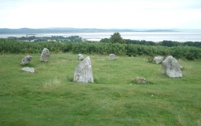
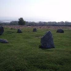
Birkrigg stone circle, Bronze Age stone circle in Ulverston, England.
Birkrigg is a Bronze Age stone circle sitting on open moorland south of Ulverston. The site consists of two concentric rings, with the outer ring containing roughly 15 stones and the inner ring holding about 10 stones positioned closer together.
The circle was built during the Bronze Age and shows signs of being used by multiple generations over time. Archaeological excavations revealed that people cremated and buried their dead at this location in dedicated areas within the rings.
The name comes from the boggy ground that once covered this area. The stones themselves mark where ancient people gathered to remember their dead and perform rituals important to their community.
The circle sits on open moorland on a hilltop with clear walking paths through heather and ferns. The site is accessible year-round, and from the top you gain wide views across the surrounding landscape.
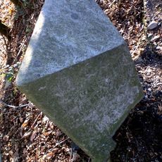
Archaeologists uncovered red ochre and stone tools during excavations, pointing to ceremonial activities beyond just burials. These discoveries suggest the site held deeper ritual significance than a simple burial ground.
Location: Ulverston
GPS coordinates: 54.15600,-3.08564
Latest update: December 6, 2025 17:42
Swarthmoor Hall
3.5 km
Conishead Priory
2.3 km
Gleaston Castle
3.9 km
St Mary and St Michael's Church, Great Urswick
2.4 km
St Michael's Church, Pennington
4.6 km
Victoria Road drill hall, Ulverston
4.2 km
Church of St Peter
4.7 km
Gleaston Water Mill
4.4 km
Church of Cuthbert
3 km
Church of Holy Trinity
1.1 km
Coronation Hall
4.3 km
Stonard Monument Approximately 18 Metres To North Of St Cuthbert Church
3 km
Ulverston War Memorial
4.5 km
Tower On Hermitage Hill At Sd 3301 4761
2.4 km
Rolling Bridge Over Ulverston Canal And Associated Accumulator Tower
4.3 km
Lindal-in-Furness War Memorial
4.6 km
Former Tollhouse In Garden Of Number 45
4.5 km
Trustee Savings Bank
4.5 km
Barclays Bank
4.3 km
Friends Meeting House
3.1 km
Canal Basin And Pier On Seaward End Of Ulverston Canal,Canal Foot
4.3 km
Aldingham Hall
3 km
Moat Farm moated site
4.1 km
Gleaston Cornmill
4.4 km
Concentric stone circle on Birkrigg Common
73 m
Milestone, Swarthmoor, SW of Three Bridges
4 km
Milestone, Pennington; E of Red Syke Bridge
3.8 km
Milestone, Lindal-in-Furness
4.5 kmVisited this place? Tap the stars to rate it and share your experience / photos with the community! Try now! You can cancel it anytime.
Discover hidden gems everywhere you go!
From secret cafés to breathtaking viewpoints, skip the crowded tourist spots and find places that match your style. Our app makes it easy with voice search, smart filtering, route optimization, and insider tips from travelers worldwide. Download now for the complete mobile experience.
A unique approach to discovering new places❞
— Le Figaro
All the places worth exploring❞
— France Info
A tailor-made excursion in just a few clicks❞
— 20 Minutes