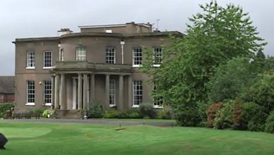
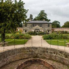
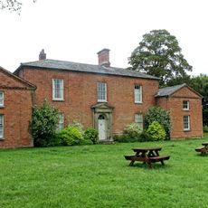
Brocton Hall, English country house in Brocton, England.
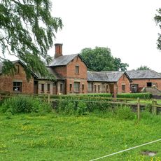
Brocton Hall is a two-story Grade II listed country house set in the Staffordshire countryside, built with architectural elements from 1760. The building now serves as a golf club headquarters, housing practice facilities and membership amenities on its grounds.
William Chetwynd built Brocton Hall in 1760, demolishing the earlier manor house on the site. The estate remained in family hands until 1923, when ownership passed to new proprietors.
The building holds memories of the Chetwynd family, with portraits of Sir George and Hannah Chetwynd painted by William Owen around 1815. These artworks reflect the lives of those who shaped this place over generations.
The building is now a golf club headquarters and may have limited visitor access depending on club policies, so it is worth checking ahead. Being set in a rural location, it is best reached by car.
A plumbing leak caused a fire in 1939 that destroyed the upper floor, reducing the building from three stories to two. This accident permanently altered the structure we see today.
Location: Brocton
Website: http://broctonhall.com
GPS coordinates: 52.77532,-2.05397
Latest update: December 14, 2025 09:45
Tixall Gatehouse
3.5 km
Milford Hall
1.4 km
Shugborough Tunnel
2.5 km
Church of St James
3.6 km
Church of Holy Trinity
3.3 km
Church of All Saints
2.2 km
Church of St John the Baptist
3.4 km
North range of outbuildings of Shugborough Park Farm
3.4 km
Dairy Bridge
3.4 km
Stafford Lodges To Shugborough Park
1.8 km
Holdiford Bridge (Over River Sow)
2.1 km
Triumphal Arch at Shugborough Hall
2.9 km
Dark Lantern at Shugborough Hall
3 km
Berkswich War Memorial Including Enclosure
2.7 km
Stafford Wood Lodge at Shugborough Hall
2.3 km
Walled Garden And Gardeners Cottage
3.3 km
Footbridge at Shugborough Park
3.5 km
Obelisk
3.1 km
River Sow Aqueduct
1.9 km
K6 Telephone Kiosk (Near Church)
3.4 km
Farmhouse of Shugborough Park Farm
3.4 km
Temple of the Winds at Shugborough Hall to north east of the house
3.5 km
Tavernor Farmily Memorial And Surrounding Railings Approximately 50 Yards South Of South Aisle Of Church Of All Saints
2.2 km
Saucer barrow on Spring Hill
1.6 km
Milepost, Milford common, E of Milford village
1.7 km
Milepost, by White Barn Farm
2.8 km
Guidestone, Holdford Road / Tixall Road jct in Tixall village
3.1 km
Milepost, E of Watton-on-the-hill
1.4 kmVisited this place? Tap the stars to rate it and share your experience / photos with the community! Try now! You can cancel it anytime.
Discover hidden gems everywhere you go!
From secret cafés to breathtaking viewpoints, skip the crowded tourist spots and find places that match your style. Our app makes it easy with voice search, smart filtering, route optimization, and insider tips from travelers worldwide. Download now for the complete mobile experience.
A unique approach to discovering new places❞
— Le Figaro
All the places worth exploring❞
— France Info
A tailor-made excursion in just a few clicks❞
— 20 Minutes