Roman Temple in Pagans Hill, Roman temple ruins in Chew Stoke, England
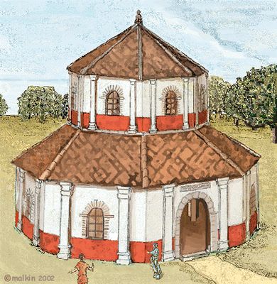
The Roman temple at Pagans Hill was a double-octagonal structure with an outer entrance hall roughly 17 meters across and an inner sanctuary about 10 meters wide, both with notably thick walls. The complex also included residential quarters for priests and a sacred well, making it function as something between a shrine and a small settlement.
This structure was built in the late period of Roman rule and underwent several reconstructions as times changed. Its final major renovation occurred shortly before Roman control faded from Britain, after which it eventually fell into ruin.
This holy place served both as a religious center and a refuge for travelers seeking shelter and spiritual connection. The combination of sacred well and residential spaces shows how deeply this site was woven into local community life.
The site today shows the foundations and lower walls of the ancient structure with pathways marking the layout of the rooms. Sturdy footwear is recommended since the ground is uneven and the ruins sit on a slope.
Excavations in the late 1940s and 1950s uncovered remarkable artifacts from several different time periods, including an unusual carved sculpture of a dog. This stone animal figure, now displayed from finds at the site, had been deliberately placed in the temple's well.
The community of curious travelers
AroundUs brings together thousands of curated places, local tips, and hidden gems, enriched daily by 60,000 contributors worldwide.