Enable Location

We need your location to show you interesting places around you

Discover nearby places

Find interesting locations and hidden gems around you

Precise directions

Get accurate directions and distances to places

Your location is never shared with other users. It's only used when you tap the location button.

Rectory Junction Viaduct

Log in to your account

Start exploring — it's free

Trusted by 62,789 travelers worldwide

Continue with Google
Continue with Apple
or

We will send you a code to connect

By continuing, you accept our Terms and Conditions and our Privacy Policy

Check your inbox

We've sent a pincode in your inbox. Please enter the code below.

Rectory Junction Viaduct

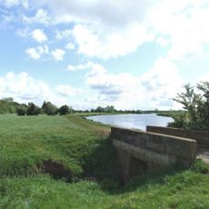
Rectory Junction Viaduct, Railway viaduct in Stoke Bardolph, United Kingdom.

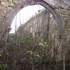
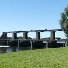
The Rectory Junction Viaduct is a railway bridge made of cast iron that spans the River Trent between Netherfield and Radcliffe-on-Trent. The structure consists of a large arch with six ribs designed to allow river traffic to pass underneath.

The viaduct was built in 1850 by Clayton & Shuttleworth of Lincoln as part of the Ambergate, Nottingham, Boston and Eastern Junction Railway development. Its original timber approach was replaced with a brick structure by Alexander Ross between 1909 and 1910.

The Grade II listed structure represents a milestone in Victorian engineering, demonstrating the technical abilities of 19th-century railway infrastructure construction.

The structure carries the Nottingham-Grantham railway line and is visible from nearby public roads, though direct access is limited. Visitors can view the bridge from various points along the river, particularly from nearby footpaths.

The approach viaduct, initially constructed in timber with 32 spans, was rebuilt in brick during 1909-1910 with 28 spans by Alexander Ross.

The community of curious travelers

AroundUs brings together thousands of curated places, local tips, and hidden gems, enriched daily by 60,000 contributors worldwide.

Start exploring
Location
Official opening
1850
GPS coordinates
52.95116,-1.05415
Latest update
December 14, 2025 14:24
Around this place
Colwick Hall
United Kingdom

Colwick Hall

3.5 km
Holme Pierrepont Hall
United Kingdom

Holme Pierrepont Hall

1.1 km
Nottingham Greyhound Stadium
United Kingdom

Nottingham Greyhound Stadium

3.7 km
St. Paul's Church, Carlton-in-the-Willows
United Kingdom

St. Paul's Church, Carlton-in-the-Willows

2.9 km
Mary Hardstaff Homes
United Kingdom

Mary Hardstaff Homes

3.7 km
St. Edmund's Church, Holme Pierrepont
United Kingdom

St. Edmund's Church, Holme Pierrepont

1.1 km
St. Mary's Church, Radcliffe on Trent
United Kingdom

St. Mary's Church, Radcliffe on Trent

991 m
St. Peter and St. Paul's Church, Shelford
United Kingdom

St. Peter and St. Paul's Church, Shelford

3.6 km
St Luke's Church, Stoke Bardolph
United Kingdom

St Luke's Church, Stoke Bardolph

2.1 km
Wollaton Road Methodist Church, Beeston
United Kingdom

Wollaton Road Methodist Church, Beeston

2.6 km
Dales United Reformed Church
United Kingdom

Dales United Reformed Church

3.7 km
Church of All Hallows
United Kingdom

Church of All Hallows

3.4 km
St John the Baptist
United Kingdom

St John the Baptist

2.6 km
Regal Cinema
United Kingdom

Regal Cinema

2.5 km
Carlton Library
United Kingdom

Carlton Library

2.6 km
Burton Joyce War Memorial
United Kingdom

Burton Joyce War Memorial

4.1 km
Simkins Farmhouse
United Kingdom

Simkins Farmhouse

4 km
Ruins of Church of St John the Baptist
United Kingdom

Ruins of Church of St John the Baptist

3.6 km
Font 2 Metres South Of West End At Church Of All Hallows
United Kingdom

Font 2 Metres South Of West End At Church Of All Hallows

3.4 km
Holme Sluices
United Kingdom

Holme Sluices

2.3 km
Shelford War Memorial
United Kingdom

Shelford War Memorial

3.5 km
St John Baptist's Church and graveyard, Colwick
United Kingdom

St John Baptist's Church and graveyard, Colwick

3.6 km
Holme House
United Kingdom

Holme House

1.6 km
Terrace And Boundary Walls At Church Of St Paul
United Kingdom

Terrace And Boundary Walls At Church Of St Paul

3 km
Footbridge Over Stream Approximately 100 Metres South East Of 28 St Helens Road
United Kingdom

Footbridge Over Stream Approximately 100 Metres South East Of 28 St Helens Road

4 km
Pillbox Square Type At Grid Ref. Sk 62259 36823
United Kingdom

Pillbox Square Type At Grid Ref. Sk 62259 36823

3.2 km
Carlton Laundry
United Kingdom

Carlton Laundry

2.6 km
Radcliffe Hall, The Royal British Legion Branch And Club
United Kingdom

Radcliffe Hall, The Royal British Legion Branch And Club

960 m
Show the full map
« Rectory Junction Viaduct - Railway viaduct in Stoke Bardolph, United Kingdom » is provided by Around Us (aroundus.com). Images and texts are derived from Wikimedia project under a Creative Commons license. You are allowed to copy, distribute, and modify copies of this page, under the conditions set by the license, as long as this note is clearly visible.

Discover hidden gems everywhere you go!

From secret cafés to breathtaking viewpoints, skip the crowded tourist spots and find places that match your style. Our app makes it easy with voice search, smart filtering, route optimization, and insider tips from travelers worldwide. Download now for the complete mobile experience.

Around Us App Screenshot

A unique approach to discovering new places

Le Figaro

All the places worth exploring

France Info

A tailor-made excursion in just a few clicks

20 Minutes

Around Us
Travel Guide & Maps
Download

Send to your phone

QR Code
1

Open the camera app on your mobile.

2

Point at the QR code with your camera. A notification will appear.

3

Tap the notification to open the link.