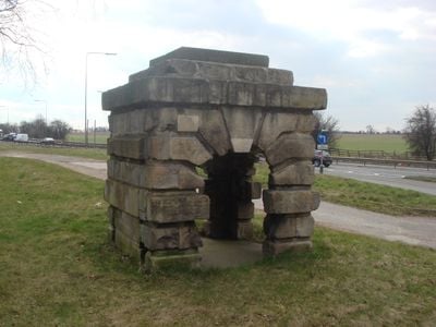
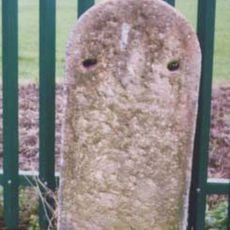
Robin Hood's Well, Grade II listed well house in Burghwallis, England
Robin Hood's Well is a small stone structure with arched openings positioned near a former spring location alongside the A1 road in South Yorkshire. The Grade II listed building demonstrates careful architectural detailing despite its modest size and continues to mark the spot where water once naturally flowed.
Sir John Vanbrugh designed this building in 1710 for the Earl of Carlisle as one of his smallest commissions. The structure was relocated in 1960 due to road expansion and later reinforced with a steel frame to ensure its survival.
The name links this structure to the local Robin Hood legend, which remains part of the region's folklore identity. This connection shapes how people understand and visit the place today.
The structure sits beside a busy main road and is easily accessible from the A1, making it straightforward to locate and view from nearby. Taking care around traffic and allowing time to appreciate the building's fine details will enhance your visit to this modest roadside landmark.
An elderly attendant once served water to passing travelers at this spot, while a nearby inn provided additional food and drink to weary journeys. Though this service has long ceased, the location still marks where people once stopped to refresh themselves during their travels.
Location: Burghwallis
GPS coordinates: 53.59975,-1.21714
Latest update: December 12, 2025 17:40
Brodsworth Hall
4.9 km
St Mary Magdalene, Campsall
3.5 km
Church of St Michael and All Angels, Brodsworth
4.7 km
Church of St Helen
1.8 km
Church of All Saints
4.3 km
Church of St Margaret
4.3 km
Church of All Saints
3.2 km
Church of St Laurence
3.8 km
Church of St Michael and All Angels
856 m
The Hostel
4.8 km
Kirk and Little Smeaton War Memorial
4.9 km
Burghwallis War Memorial
1.4 km
Picture House
4.5 km
Old Stables To Brodsworth Hall
4.8 km
Milepost In Front Of Milestone House
4.4 km
The Old Bells And The Chimneys With Self Contained Flat
3.3 km
Home Farmhouse
4.8 km
Milepost Approximately 180 Metres South Of Junction With Holme Lane
4.5 km
Milestone, Skellow, N of Hampole Balk Lane, B1220, 250m from jct
849 m
Manor Farmhouse
4.7 km
Rock Farmhouse
4.8 km
Owston Hall Flats 1 To 5 And Including The Old Hall
3.2 km
Watchley Farmhouse
4.8 km
Barn Immediately To South East Of Watchley Farmhouse
4.8 km
Milestone, at fork of A19 and UC road to Sutton & Campsall
3.7 km
Milestone, Barnsdale Bar jct with A1
2.3 km
Milestone, 1 mile N of jct with A1
3.9 km
Milestone, Adwick between Tenter Balk Lane & Windmill Balk Lane
4 kmVisited this place? Tap the stars to rate it and share your experience / photos with the community! Try now! You can cancel it anytime.
Discover hidden gems everywhere you go!
From secret cafés to breathtaking viewpoints, skip the crowded tourist spots and find places that match your style. Our app makes it easy with voice search, smart filtering, route optimization, and insider tips from travelers worldwide. Download now for the complete mobile experience.
A unique approach to discovering new places❞
— Le Figaro
All the places worth exploring❞
— France Info
A tailor-made excursion in just a few clicks❞
— 20 Minutes