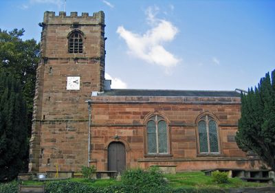
St Peter's Church, Little Budworth, Anglican church in Little Budworth, England
St Peter's Church sits at the highest point of Little Budworth and features a prominent tower built from red sandstone with a slate roof. The structure combines elements from different periods, with a late medieval west tower and a main body that was reconstructed in the neoclassical style.
The roots of the building trace back to the 12th century, when an early church was first established at this location. The current west tower was added in the late medieval period, while the main body received its present form during the early 1800s.
The church remains a gathering place for the community of Little Budworth, serving its role as a local spiritual center. Walking through the graveyard, you notice names and inscriptions that reflect the long relationship between the building and its people.
The church operates as an active parish and it is worth checking opening times in advance since it is used for services. The graveyard surrounding the building is typically open to visitors and provides a peaceful setting to explore the exterior and surrounding landscape.
Inside the church are unusual pieces such as a Georgian pulpit and a painted font from the 17th century, showing how religious spaces were furnished over time. Additionally, memorials to soldiers who died in the Crimean War connect the building to significant moments in British history.
The community of curious travelers
AroundUs brings together thousands of curated places, local tips, and hidden gems, enriched daily by 60,000 contributors worldwide.