Enable Location

We need your location to show you interesting places around you

Discover nearby places

Find interesting locations and hidden gems around you

Precise directions

Get accurate directions and distances to places

Your location is never shared with other users. It's only used when you tap the location button.

Stanthorne Hall

Log in to your account

Join the adventure

Create your free account and start exploring (like 60k+ others)

We will send you a code to connect

or
Continue with Google
Continue with Apple
By continuing, you accept our Terms and Conditions and our Privacy Policy

Check your inbox

We've sent a pincode in your inbox. Please enter the code below.

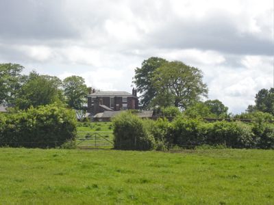
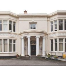
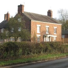
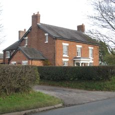
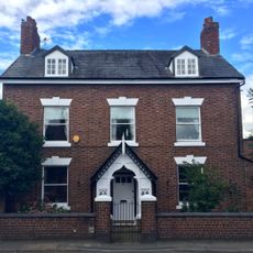
Stanthorne Hall, Grade II listed country house in Stanthorne, England

Description

Stanthorne Hall is an early 19th-century country house with plum-colored Flemish bond brick walls, painted stone dressings, and a symmetrical three-story entrance front divided into three bays. The building combines classical proportions with crafted details typical of prosperous country estates from that era.

History

The hall was built between 1804 and 1807 as a residential estate under Richard Dutton's direction in Cheshire. The construction methods and design of those years shaped a generation of country houses that paired Georgian refinement with skilled craftsmanship.

Culture

The interior displays crafted details like enriched cornices with triglyphs and black marble chimneys with quarter-columns in the ground floor rooms. These elements reflect the tastes of wealthy households during the early 1800s.

Practical

The building sits along Middlewich Road and is easy to reach via local routes. Wear sturdy shoes since the grounds feature typical English countryside, and morning visits work best when light highlights the brick details beautifully.

Did you know?

The first-floor fire surrounds still retain their original hob grates, offering a glimpse into everyday household systems from the early 1800s. These working elements show how people actually lived and heated their homes back then.

GPS coordinates
53.19510,-2.47777
Latest update
December 14, 2025 16:40

AroundUs brings together thousands of curated places, local tips, and hidden gems, enriched daily by 60,000 contributors worldwide. Discover all places nearby (Stanthorne and Wimboldsley).

Around this place
St Michael and All Angels, Middlewich
United Kingdom

St Michael and All Angels, Middlewich

2.2 km
Bostock Hall
United Kingdom

Bostock Hall

1.8 km
Christ Church, Wharton
United Kingdom

Christ Church, Wharton

1.9 km
Middlewich Manor
United Kingdom

Middlewich Manor

2.1 km
Middlewich Town Hall
United Kingdom

Middlewich Town Hall

2.3 km
10, Hightown
United Kingdom

10, Hightown

2.2 km
Trent and Mersey Canal, Big Lock and footbridge
United Kingdom

Trent and Mersey Canal, Big Lock and footbridge

2 km
Sundial south of west bay of Church of St Michael and All Angels, Middlewich
United Kingdom

Sundial south of west bay of Church of St Michael and All Angels, Middlewich

2.2 km
Kinderton Mill
United Kingdom

Kinderton Mill

2.3 km
25, Queen Street
United Kingdom

25, Queen Street

2.2 km
Old Hall Farmhouse
United Kingdom

Old Hall Farmhouse

879 m
Trent and Mersey Canal, canal milepost at NGR 698 670
United Kingdom

Trent and Mersey Canal, canal milepost at NGR 698 670

1.7 km
Middlewich Branch of Shropshire Union: Canal Bridge Number 30 carrying St Ann's Road over canal
United Kingdom

Middlewich Branch of Shropshire Union: Canal Bridge Number 30 carrying St Ann's Road over canal

2.3 km
Middlewich Branch of Shropshire Union Canal: Bridge Number 28 carrying footpath over canal
United Kingdom

Middlewich Branch of Shropshire Union Canal: Bridge Number 28 carrying footpath over canal

2 km
Gates and railings to Middlewich Cemetery
United Kingdom

Gates and railings to Middlewich Cemetery

1.7 km
Cooke family tomb in Middlewich Cemetery circa 80 metres south of mortuary chapels
United Kingdom

Cooke family tomb in Middlewich Cemetery circa 80 metres south of mortuary chapels

1.7 km
28, Wheelock Street
United Kingdom

28, Wheelock Street

2 km
Stanthorne Mill
United Kingdom

Stanthorne Mill

1.3 km
8, Southway
United Kingdom

8, Southway

1.9 km
Mortuary chapels, archway and spire in Middlewich Cemetery
United Kingdom

Mortuary chapels, archway and spire in Middlewich Cemetery

1.7 km
Bank Farmhouse
United Kingdom

Bank Farmhouse

720 m
Milepost
United Kingdom

Milepost

614 m
66, St Ann's Road
United Kingdom

66, St Ann's Road

2 km
Milepost, Bostock Road
United Kingdom

Milepost, Bostock Road

1.6 km
62, St Ann's Road
United Kingdom

62, St Ann's Road

2 km
Nantwich Road Aqueduct
United Kingdom

Nantwich Road Aqueduct

1.7 km
64, St Ann's Road
United Kingdom

64, St Ann's Road

2 km
Milepost, S of Sheriff House
United Kingdom

Milepost, S of Sheriff House

1.7 km
Show the full map
« Stanthorne Hall - Grade II listed country house in Stanthorne, England » is provided by Around Us (aroundus.com). Images and texts are derived from Wikimedia project under a Creative Commons license. You are allowed to copy, distribute, and modify copies of this page, under the conditions set by the license, as long as this note is clearly visible.

Discover hidden gems everywhere you go!

From secret cafés to breathtaking viewpoints, skip the crowded tourist spots and find places that match your style. Our app makes it easy with voice search, smart filtering, route optimization, and insider tips from travelers worldwide. Download now for the complete mobile experience.

Around Us App Screenshot

A unique approach to discovering new places

Le Figaro

All the places worth exploring

France Info

A tailor-made excursion in just a few clicks

20 Minutes

Around Us
Travel Guide & Maps
Download

Send to your phone

QR Code
1

Open the camera app on your mobile.

2

Point at the QR code with your camera. A notification will appear.

3

Tap the notification to open the link.