Chiselbury, Iron Age hillfort in Fovant, England
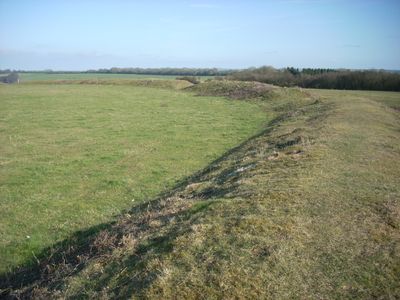
Chiselbury is an Iron Age fortification in Fovant that encloses roughly 10 acres of land with defensive ramparts and an outer ditch system. The structure shows a circular earthwork layout where the raised banks and ditches remain clearly visible despite thousands of years of weathering.
The hillfort was built during the Iron Age to serve as a defensive stronghold for communities in the area. Later, Roman settlers left behind coins and objects at and near the site, showing it remained significant even after its original use ended.
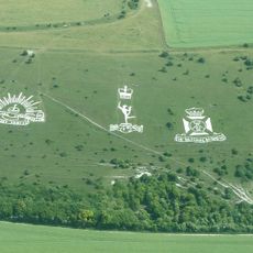
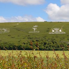
The site links ancient defense structures with military heritage through its closeness to the Fovant Badges, inscriptions carved into the hillside during World War I by stationed soldiers. This connection shows how the place was used across centuries for defense and community marking.
Multiple public footpaths and bridleways approach this protected monument from the east and south, offering good vantage points from the elevated location. The site is freely accessible and needs only standard walking shoes and weather protection.
Two cross dykes flank the main fortification and extend across the landscape at different lengths. These additional earthworks show how defense extended beyond the inner ring.
Location: Fovant
GPS coordinates: 51.05220,-1.97570
Latest update: December 14, 2025 16:47
Reddish House
3.5 km
Fovant Badges
235 m
Compton Park House
2.3 km
Church of St Michael, Compton Chamberlayne
2.3 km
Church of All Saints
3.6 km
Church of St George
2.6 km
Church of St Martin
3 km
Church of St Edith of Wilton
3.7 km
Church of St Mary the Virgin
3.7 km
Church of All Saints
3.3 km
Milestone About 150 Metres East Of Lodge To Compton Park
1.9 km
Congregational Chapel
1.6 km
Old Schoolroom
3.8 km
Hydes House
3.7 km
Reddish House Cottages
3.5 km
Speargate
3.9 km
Milestone Approximately 150 Metres West Of Junction With Baverstock Lane
3.4 km
Two chalk military badges 380m and 550m west of Sheep Well
3.6 km
Milestone About 50 Metres West Of Dinton First School
3.4 km
Milestone About 150 Metres West Of West Farm
1.4 km
Milestone Approximately 200 Metres East Of Manor Farm
2.9 km
Milestone About 200 Metres East Of Drive To Lower Hurdcott Farm
3.4 km
The Lodge
3.9 km
Fitz Farmhouse
3.5 km
Kings Old Rectory
3.5 km
Churchyard Sundial About 10 Metres South Of Chancel Of Church Of All Saints
3.3 km
Milestone, Barford Heath; 200m E entrance Hurdcott Farms
3.4 km
Milestone, Great Wurs Copse; 150m W entrance Compton Mills
1.1 kmVisited this place? Tap the stars to rate it and share your experience / photos with the community! Try now! You can cancel it anytime.
Discover hidden gems everywhere you go!
From secret cafés to breathtaking viewpoints, skip the crowded tourist spots and find places that match your style. Our app makes it easy with voice search, smart filtering, route optimization, and insider tips from travelers worldwide. Download now for the complete mobile experience.
A unique approach to discovering new places❞
— Le Figaro
All the places worth exploring❞
— France Info
A tailor-made excursion in just a few clicks❞
— 20 Minutes