Dorton House, Buckinghamshire

Log in to your account

AroundUs is a community-driven map of interesting places, built by curious explorers like you. It grows with every review, story, and photo you share.
Connect to save your favorite spots, contribute locations, and create personalized routes.
Continue with Google
Continue with Apple
Continue with X
Continue with Facebook
Continue with email
By continuing, you accept our Terms and Conditions and our Privacy Policy
Create an account
Add to collection
Map
Suggest a change
Share

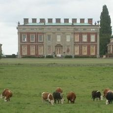
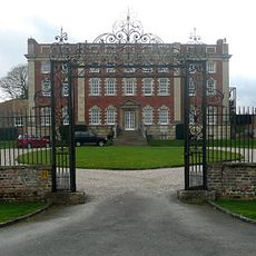
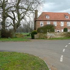
Dorton House, Buckinghamshire, Grade I listed country house in Aylesbury Vale, England.

Dorton House is an English country house in Aylesbury Vale featuring a distinctive horseshoe-shaped layout built with bricks made from local clay sources. The complex now functions as Ashfold School for children aged 3 to 13 and displays characteristic Jacobean architectural elements.

The house was constructed between 1596 and 1626 under the ownership of Sir John Dormer, before passing to the Fletcher family in 1783. A datestone on the building indicates 1626, though some historians propose a later construction date based on architectural analysis.

The building served as an educational facility for the Royal London Society for the Blind from 1939 to 1955, marking a meaningful shift in how the space was used. This educational purpose continues to shape how people experience the place today.

Visitors can observe the exterior architecture and grounds of the house as it functions as a school campus for Ashfold School. Plan time to explore the facade and garden areas surrounding the building.

The building displays a datestone showing 1626 on its exterior soffit, yet historians Elizabeth Williamson and Nikolaus Pevsner propose a considerably later construction date based on architectural style. This mismatch between the visible date and scholarly analysis keeps the true building timeline intriguingly uncertain.

Location: Aylesbury Vale

Location: Dorton

GPS coordinates: 51.81960,-1.01564

Latest update: December 14, 2025 09:42

Photos
Around this place
Wotton House
United Kingdom

Wotton House

2.4 km
Rushbeds Wood
United Kingdom

Rushbeds Wood

2 km
Stoke Common
United Kingdom

Stoke Common

4.2 km
Muswell Hill, Buckinghamshire
United Kingdom

Muswell Hill, Buckinghamshire

4.2 km
Brill Windmill
United Kingdom

Brill Windmill

2.8 km
Parish Church of St Mary the Virgin
United Kingdom

Parish Church of St Mary the Virgin

2.6 km
Church of St John the Baptist, Dorton
United Kingdom

Church of St John the Baptist, Dorton

74 m
Church of All Saints, Wotton Underwood
United Kingdom

Church of All Saints, Wotton Underwood

2.2 km
Church of St Mary
United Kingdom

Church of St Mary

4.1 km
Church of St Mary
United Kingdom

Church of St Mary

3.8 km
Parish Church of St Mary, Chilton
United Kingdom

Parish Church of St Mary, Chilton

2.4 km
Church of All Saints
United Kingdom

Church of All Saints

2.3 km
Moat Farmhouse
United Kingdom

Moat Farmhouse

4 km
The Chandos Arms
United Kingdom

The Chandos Arms

4.4 km
K1 Test Stand, Control Room And Ancillary Building, Former Royal Ordnance Establishment, Westcott
United Kingdom

K1 Test Stand, Control Room And Ancillary Building, Former Royal Ordnance Establishment, Westcott

3.9 km
K2 Test Stand, Former Royal Ordnance Establishment, Westcott
United Kingdom

K2 Test Stand, Former Royal Ordnance Establishment, Westcott

3.9 km
Chilton House Including Forecourt Walls, Gates, Railings And Pavilions Clock Tower
United Kingdom

Chilton House Including Forecourt Walls, Gates, Railings And Pavilions Clock Tower

2.4 km
War Memorial
United Kingdom

War Memorial

2.5 km
Corble Farmhouse
United Kingdom

Corble Farmhouse

4.6 km
The Gatehouse
United Kingdom

The Gatehouse

2.5 km
P Test-Stands And Support Structures, Former Royal Ordnance Establishment, Westcott
United Kingdom

P Test-Stands And Support Structures, Former Royal Ordnance Establishment, Westcott

4.7 km
Milepost, Woodway Farm, 10m to right of entrance
United Kingdom

Milepost, Woodway Farm, 10m to right of entrance

3.9 km
Milepost, Hornage Farm
United Kingdom

Milepost, Hornage Farm

3.2 km
Milepost, Thame Road; opp. Oakley Church
United Kingdom

Milepost, Thame Road; opp. Oakley Church

4.1 km
Milepost, Foresters; Boarstall Wood
United Kingdom

Milepost, Foresters; Boarstall Wood

4.6 km
Milepost, Kingswood Lane; Long Wood, N of turn to Clearfields Farm
United Kingdom

Milepost, Kingswood Lane; Long Wood, N of turn to Clearfields Farm

2.7 km
Milepost, Kingswood Lane; N of Windmill Hill
United Kingdom

Milepost, Kingswood Lane; N of Windmill Hill

3.9 km
Milepost, just N of Little Green, Leatherslade Farm (500m)
United Kingdom

Milepost, just N of Little Green, Leatherslade Farm (500m)

3.1 km
Show the full map
Reviews

Visited this place? Tap the stars to rate it and share your experience / photos with the community! Try now! You can cancel it anytime.

« Dorton House, Buckinghamshire - Grade I listed country house in Aylesbury Vale, England » is provided by Around Us (aroundus.com). Images and texts are derived from Wikimedia project under a Creative Commons license. You are allowed to copy, distribute, and modify copies of this page, under the conditions set by the license, as long as this note is clearly visible.

Discover hidden gems everywhere you go!

From secret cafés to breathtaking viewpoints, skip the crowded tourist spots and find places that match your style. Our app makes it easy with voice search, smart filtering, route optimization, and insider tips from travelers worldwide. Download now for the complete mobile experience.

Around Us App Screenshot

A unique approach to discovering new places

Le Figaro

All the places worth exploring

France Info

A tailor-made excursion in just a few clicks

20 Minutes