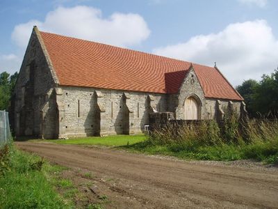
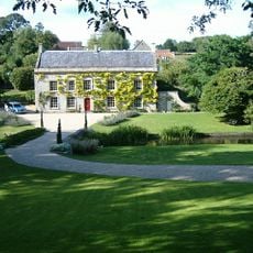
Tithe Barn, Medieval tithe barn in Pilton, England
Tithe Barn is a stone structure extending across nine bays with tall narrow openings along its walls. The roof employs a raised cruck construction and features four gables decorated with evangelist symbols.
Built between 1322 and 1334 under Abbot Adam de Sodbury of Glastonbury Abbey, the barn served as storage for agricultural produce. It represents the economic power and extensive landholdings of the monastic community.
The barn embodies medieval religious taxation where local farmers contributed one-tenth of their annual produce to the church. This practice shaped the relationship between rural communities and ecclesiastical authority for centuries.
The building now functions as a community venue for weddings, fairs, and public events with spacious interior areas. Its solid stone construction ensures it remains accessible in most weather conditions.
A lightning strike destroyed the thatched roof in 1963, leaving the barn in ruins for decades. Michael Eavis purchased and carefully restored it using traditional materials in 1995, bringing it back to working condition.
Location: Pilton
Inception: 12 century
GPS coordinates: 51.16340,-2.58915
Latest update: December 11, 2025 11:08
Church of All Saints, East Pennard
3.3 km
The Old Hall
3.7 km
Church of St John the Baptist
184 m
Church of St Mary the Virgin, Croscombe
3.8 km
Twinhills Woods and Meadows
4 km
Church of St Thomas à Becket
2.9 km
Church of St Peter
2.8 km
Pilton War Memorial
360 m
Pylle Manor And Attached Walled Garden At Rear
3 km
Bowlish House
4.1 km
Mile Post At Ngr St 5733 3990
1.7 km
Roadside Cross In Garden Of Cross Cottage At Ngr St 5727 4304
2.9 km
Wall Enclosing Garden Of Old Ham Manor
4 km
Village Cross adjacent to the Bull Terrier
3.7 km
Milepost On Roadside At Ngr St 6297 4085
4.1 km
The Manor House And Attached Wall To Rear
166 m
Milepost, N of Beard Hill & S of jct with A361
3.5 km
Milepost On Roadside At Ngr St 6002 4145
1.4 km
Milepost South West Of Pilton School House
298 m
Mile Post At Ngr St 5588 3919
3.3 km
Milepost On Roadside At Ngr St 6090 4271
2.9 km
No 65 And Carriageway Entrance
4 km
The Old Manor
3.7 km
Milepost, Street on the Fosse, nr Bridge Farm
3.3 km
Milestone, Long Street, in village of Croscombe
3.7 km
Milepost, just N of Cannard's Grave, near Gore End Farm
3.9 km
Milepost, W of Darshill, nr sewage works
3.6 km
Ashley House
3.7 kmVisited this place? Tap the stars to rate it and share your experience / photos with the community! Try now! You can cancel it anytime.
Discover hidden gems everywhere you go!
From secret cafés to breathtaking viewpoints, skip the crowded tourist spots and find places that match your style. Our app makes it easy with voice search, smart filtering, route optimization, and insider tips from travelers worldwide. Download now for the complete mobile experience.
A unique approach to discovering new places❞
— Le Figaro
All the places worth exploring❞
— France Info
A tailor-made excursion in just a few clicks❞
— 20 Minutes