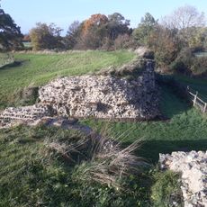
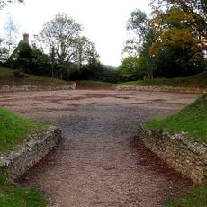
The Frith, Iron Age hillfort in Mortimer West End, England.
The Frith is an Iron Age fortification whose distinctive earthwork ramparts and ditches remain clearly visible across the landscape. The structure utilizes the natural elevation of the terrain to establish a strategic defensive position.
The fortification arose during the Iron Age as a response to the defensive needs of local communities in the region. Archaeological evidence suggests that the site remained in use across multiple generations.
The earthworks visible today reflect how Iron Age people organized their defensive space using natural contours and manual labor. Walking around the site, you can sense how communities shaped the landscape to protect themselves.
The site is best explored on foot, and sturdy footwear helps since the ground is uneven due to the ancient ramparts and ditches. Plan enough time to walk slowly across the structures and bring weather-appropriate clothing.
Hobbyists with metal detectors have regularly made finds here that shed light on Iron Age daily life and activities. These smaller objects add to the bigger picture archaeologists build and reveal overlooked details about life back then.
Location: Mortimer West End
GPS coordinates: 51.36330,-1.10116
Latest update: December 14, 2025 16:43
Calleva Atrebatum
1.5 km
Ufton Court
3.7 km
Aldermaston Court
3.4 km
Church of St Mary the Virgin, Aldermaston
3.6 km
Church of St James
4.5 km
Pamber Forest and Silchester Common
2.5 km
Calleva Atrebatum
1.4 km
Silchester House
1.2 km
Padworth Lock
4.6 km
Church of St Peter
4.2 km
Church of St John the Baptist
3.4 km
Church of St Peter
4.5 km
Church of St Mary Church of St Mary 66826410
4.3 km
Church of St. Mary
1.8 km
The Hind's Head Inn
4.3 km
Countess Of Huntingdon's Chapel
1.5 km
Silchester Amphitheatre
1.9 km
Mortimer Station
4.7 km
Dial Cottage
1.1 km
Saint Paul's Church
3.2 km
North East Lodges And Gates To Aldermaston Court
4.1 km
Waiting Room At Mortimer Station On South West Side Of Railway Line
4.7 km
Old Bells House
4.6 km
The Late Iron Age oppidum and Roman town of Calleva Atrebatum and associated features
1.4 km
The Mount Farmhouse
1.8 km
Old Manor Farmhouse
1.8 km
Tadley Library
3 km
Mortimer West End War Memorial
893 mVisited this place? Tap the stars to rate it and share your experience / photos with the community! Try now! You can cancel it anytime.
Discover hidden gems everywhere you go!
From secret cafés to breathtaking viewpoints, skip the crowded tourist spots and find places that match your style. Our app makes it easy with voice search, smart filtering, route optimization, and insider tips from travelers worldwide. Download now for the complete mobile experience.
A unique approach to discovering new places❞
— Le Figaro
All the places worth exploring❞
— France Info
A tailor-made excursion in just a few clicks❞
— 20 Minutes