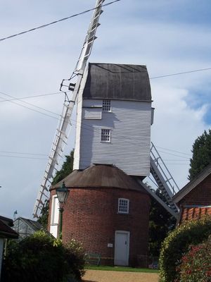
Webster's Mill, Framsden, Grade II* listed post mill in Framsden, England.
Webster's Mill is a wooden post mill with four sails built to grind grain for local farmers. The structure sits on a roundhouse foundation and contains two pairs of millstones, powered by sails that catch the wind from any direction thanks to an automatic turning mechanism.
The mill was built in 1760 to serve a farming community that needed grain processing. In 1836 it was raised significantly and fitted with improvements that made it work more efficiently for the people who depended on it.
The mill shows how rural communities worked with grain and used water-powered machinery to survive. Walking through it today reveals the practical skills and knowledge that shaped agricultural life in the region.
The mill is visible from outside and shows how sails and mechanical parts work together to process grain. Visitors can see the rotating mechanism and understand how the structure automatically adjusted to catch the wind efficiently.
This mill ranks among the tallest of its kind in Suffolk, a distinction that made it stand out in the agricultural landscape. The height gave it better access to consistent wind patterns, which was crucial for grinding grain reliably.
Location: Framsden
GPS coordinates: 52.19240,1.20530
Latest update: December 14, 2025 17:02
Helmingham Hall
2.1 km
Fox Fritillary Meadow
891 m
Church of St Andrew
2.2 km
Church of St Mary
899 m
Church of St Peter
3.6 km
Church of St Mary, Helmingham
2.1 km
Church of St Catherine
2.4 km
Church of St Mary
3.4 km
Helmingham Hall Gardens
2.1 km
The Cherry Tree Inn, Debenham
3.6 km
The Greyhound Inn, Framsden
633 m
Winston War Memorial
2.2 km
Framsden War Memorial
898 m
Cretingham War Memorial
3.7 km
New Bell Public House
3.7 km
Male Statue, 5 Metres South West Of The North West Corner Of Moat Surrounding Helmingham Hall
2.2 km
Front Lodge And Screen Wall To Left
2.4 km
Obelisk, About 750 Metres West Of Helmingham Hall
2.5 km
Sundial, 30 Metres South West Of West Elevation Of Helmingham Hall
2.2 km
72 And 74, High Street
3.7 km
Entrance Gateway And Piers To Helmingham Park, Between Front Lodges To Oak Walk
2.3 km
The Old Rectory
2.1 km
2 And 3, Cross Green
3.8 km
64 And 66, High Street
3.8 km
56, High Street
3.8 km
Female Statue, 5 Metres South West Of The South West Corner Of Moat Surrounding Helmingham Hall
2.1 km
Crows Hall (including Bridge Over Moat And Walling Lining Inner Side Of Moat To West And South)
3.1 km
Urn, 60 Metres South West Of Centre Of West Elevation Of Helmingham Hall
2.2 kmVisited this place? Tap the stars to rate it and share your experience / photos with the community! Try now! You can cancel it anytime.
Discover hidden gems everywhere you go!
From secret cafés to breathtaking viewpoints, skip the crowded tourist spots and find places that match your style. Our app makes it easy with voice search, smart filtering, route optimization, and insider tips from travelers worldwide. Download now for the complete mobile experience.
A unique approach to discovering new places❞
— Le Figaro
All the places worth exploring❞
— France Info
A tailor-made excursion in just a few clicks❞
— 20 Minutes