Enable Location

We need your location to show you interesting places around you

Discover nearby places

Find interesting locations and hidden gems around you

Precise directions

Get accurate directions and distances to places

Your location is never shared with other users. It's only used when you tap the location button.

Uley Bury

Log in to your account

Start exploring — it's free

Trusted by 67,024 travelers worldwide

Continue with Google
Continue with Apple
or

We will send you a code to connect

By continuing, you accept our Terms and Conditions and our Privacy Policy

Check your inbox

We've sent a pincode in your inbox. Please enter the code below.

Discussion Reviews 2 Photos
2.9k Popularity

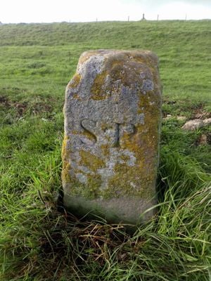
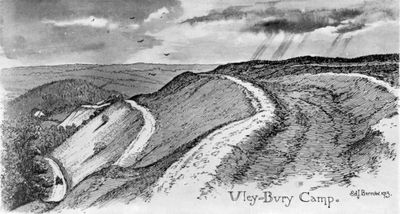
Uley Bury, Iron Age hill fort in Gloucestershire, England.

Uley Bury is an Iron Age fort featuring double ramparts that run along the Cotswold escarpment, creating a series of defensive lines across the hilltop. The fortification covers a substantial area with multiple defensive barriers arranged in parallel formation.

The fort was founded during the Iron Age and remained occupied across several centuries until the Roman period arrived in Britain. Excavations conducted decades ago uncovered material evidence spanning both the Iron Age and Roman times.

The site reflects how Iron Age communities chose hilltop locations to establish protected settlements within the Cotswold landscape. Visitors can observe how the fortification layout relates to the surrounding geography today.

Access is available via marked footpaths from the B4066 road at Crawley Hill, or through longer hiking routes that connect to the site. The terrain is rolling and hilly, so sturdy footwear and proper walking gear are advisable for exploring the fort.

The location protects geological layers rich in ancient marine fossils, including numerous specimens of coiled shells from the sea. This combination of archaeological remains and fossil deposits makes the site valuable to both historians and scientists studying prehistoric life.

The community of curious travelers

AroundUs brings together thousands of curated places, local tips, and hidden gems, enriched daily by 60,000 contributors worldwide.

Start exploring
Location
GPS coordinates
51.68855,-2.31314
Latest update
March 10, 2026 19:36
Around this place
Church of St Giles
United Kingdom

Church of St Giles

754 m
United Kingdom

Nathaniel Long Memorial, Circa 8 Metres South Of South West Corner At Church Of St Giles

749 m
United Kingdom

Group Of Five Memorials Circa 6 Metres West Of West Wall At Church Of St Giles

739 m
United Kingdom

52, The Street

737 m
Milestone At Ngr St787992
United Kingdom

Milestone At Ngr St787992

387 m
United Kingdom

Westholme

738 m
United Kingdom

50, The Street

732 m
United Kingdom

Unidentified Memorial, Circa 7 Metres South West Of South West Corner At Church Of St Giles

742 m
United Kingdom

35, The Street

743 m
United Kingdom

The Yews

706 m
United Kingdom

53 And 55, The Street

706 m
United Kingdom

Dimery Tomb Circa 11 Metres South West Of South West Corner, At Church Of St Giles

741 m
United Kingdom

Unidentified Chest Tomb Circa 10 Metres West Of South West Corner, At Church Of St Giles

735 m
United Kingdom

56, The Street

734 m
United Kingdom

49, The Street

691 m
United Kingdom

36, The Street

750 m
United Kingdom

Former Brewhouse Attached To Number 29 On South West Side

717 m
United Kingdom

No 69 Foxgloves

744 m
United Kingdom

Unidentified Chest Tomb Circa 13 Metres West Of Buttress On West Wall, At Church Of St Giles

734 m
United Kingdom

Chest Tomb, Circa 5 Metres South West Of South West Corner At Church Of St Giles

745 m
United Kingdom

Two Unidentified Memorials Circa 16 Metres South West Of Porch Door At Church Of St Giles

748 m
United Kingdom

Weaver's House

739 m
United Kingdom

Post Office

734 m
United Kingdom

Unidentified Chest Tomb, Circa 15 Metres South West Of South West Corner, At Church Of St Giles

736 m
United Kingdom

Unidentified Chest Tomb Circa 12 Metres South West Of South West Corner At Church Of St Giles

742 m
United Kingdom

Unidentified Chest Tomb, Circa 7 Metres South West Of South West Corner At Church Of St Giles

744 m
United Kingdom

Robinson, Ashmead And One Unidentified Memorial Circa 10 To 13 Metres South Of Porch Door At Church Of St Giles

752 m
United Kingdom

Scenic viewpoint

469 m
Show the full map
Reviews
Share your experience

No review yet

Discussions
Start a discussion...

No discussion yet

« Uley Bury - Iron Age hill fort in Gloucestershire, England » is provided by Around Us (aroundus.com). Images and texts are derived from Wikimedia project under a Creative Commons license. You are allowed to copy, distribute, and modify copies of this page, under the conditions set by the license, as long as this note is clearly visible.

Discover hidden gems everywhere you go!

From secret cafés to breathtaking viewpoints, skip the crowded tourist spots and find places that match your style. Our app makes it easy with voice search, smart filtering, route optimization, and insider tips from travelers worldwide. Download now for the complete mobile experience.

Around Us App Screenshot

A unique approach to discovering new places

Le Figaro

All the places worth exploring

France Info

A tailor-made excursion in just a few clicks

20 Minutes

Around Us
Travel Guide & Maps
Download

Send to your phone

QR Code
1

Open the camera app on your mobile.

2

Point at the QR code with your camera. A notification will appear.

3

Tap the notification to open the link.