Enable Location

We need your location to show you interesting places around you

Discover nearby places

Find interesting locations and hidden gems around you

Precise directions

Get accurate directions and distances to places

Your location is never shared with other users. It's only used when you tap the location button.

Pontrilas Army Training Area

Log in to your account

Start exploring — it's free

Trusted by 62,272 travelers worldwide

Continue with Google
Continue with Apple
or

We will send you a code to connect

By continuing, you accept our Terms and Conditions and our Privacy Policy

Check your inbox

We've sent a pincode in your inbox. Please enter the code below.

Pontrilas Army Training Area

Pontrilas Army Training Area, Military training facility in Herefordshire, United Kingdom

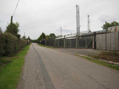
Pontrilas Army Training Area is a military facility located north of Pontrilas village in Herefordshire. The complex features specialized zones designed for different exercise types and tactical training scenarios across its sprawling grounds.

The site began as an ammunition storage depot before World War II and was connected to the national rail network through a branch line. Over time it evolved into a modern training facility for military operations and special forces preparation.

The site holds a vital place in local military identity, serving generations of armed forces personnel who trained here before deployment. The presence of this facility shapes how nearby residents view their region's role in national defense.

The training area is closed to the public due to ongoing military operations and active training exercises. Visitors can only view the facility from outside its perimeter, as strict security protocols are in place.

A decommissioned aircraft replica within the grounds serves as a training tool for tactical scenarios. This allows military personnel to practice air operations in controlled, realistic settings.

The community of curious travelers

AroundUs brings together thousands of curated places, local tips, and hidden gems, enriched daily by 60,000 contributors worldwide.

Start exploring
GPS coordinates
51.96560,-2.87611
Latest update
December 10, 2025 15:58
Around this place
Abbey Dore Court
United Kingdom

Abbey Dore Court

1.4 km
Dore Abbey
United Kingdom

Dore Abbey

1.2 km
Ewyas Harold Castle
United Kingdom

Ewyas Harold Castle

1.9 km
St James's Church
United Kingdom

St James's Church

4.4 km
Pontrilas Court
United Kingdom

Pontrilas Court

2.6 km
Great House Farm
United Kingdom

Great House Farm

4.2 km
Church of St Michael and All Angels
United Kingdom

Church of St Michael and All Angels

1.7 km
Church of St Dubricius, at St Devereux, Herefordshire
United Kingdom

Church of St Dubricius, at St Devereux, Herefordshire

4.3 km
Church of St Peter and St Thomas
United Kingdom

Church of St Peter and St Thomas

2.9 km
Church of St Mary
United Kingdom

Church of St Mary

1.7 km
Church of St Michael
United Kingdom

Church of St Michael

2.8 km
Church of St Peter
United Kingdom

Church of St Peter

3.9 km
Church of St Mary
United Kingdom

Church of St Mary

1.2 km
Milestone About 1080 Yards Ene Of Church Of St Faith
United Kingdom

Milestone About 1080 Yards Ene Of Church Of St Faith

3.1 km
Church of St Faith
United Kingdom

Church of St Faith

3.7 km
The Obelisk
United Kingdom

The Obelisk

1.8 km
Group of 7 monuments about 10-20 yards south and south-west of the south porch of the Church of St Mary
United Kingdom

Group of 7 monuments about 10-20 yards south and south-west of the south porch of the Church of St Mary

1.3 km
Gates and gate piers about 30 yards north-north-east of The Old Rectory
United Kingdom

Gates and gate piers about 30 yards north-north-east of The Old Rectory

1.2 km
Cwm Farmhouse
United Kingdom

Cwm Farmhouse

1.8 km
Hollingwood Farmhouse
United Kingdom

Hollingwood Farmhouse

3 km
Cross in St James's Churchyard
United Kingdom

Cross in St James's Churchyard

4.4 km
Milestone, Howton Farm
United Kingdom

Milestone, Howton Farm

1.6 km
Milepost, Morehampton Park; 140m N Farmhouse Farm entrance
United Kingdom

Milepost, Morehampton Park; 140m N Farmhouse Farm entrance

4.3 km
Stables about 25 yards north-east of The Old Rectory
United Kingdom

Stables about 25 yards north-east of The Old Rectory

1.2 km
Milestone, Howton Grove Farm
United Kingdom

Milestone, Howton Grove Farm

2.5 km
Milepost, Elms Farm
United Kingdom

Milepost, Elms Farm

3.7 km
Milepost, Dore, 350m S Pen-twyn Cottage
United Kingdom

Milepost, Dore, 350m S Pen-twyn Cottage

2.3 km
Milepost, Dore; 10m N Dicks Pitch turn
United Kingdom

Milepost, Dore; 10m N Dicks Pitch turn

990 m
Show the full map
« Pontrilas Army Training Area - Military training facility in Herefordshire, United Kingdom » is provided by Around Us (aroundus.com). Images and texts are derived from Wikimedia project under a Creative Commons license. You are allowed to copy, distribute, and modify copies of this page, under the conditions set by the license, as long as this note is clearly visible.

Discover hidden gems everywhere you go!

From secret cafés to breathtaking viewpoints, skip the crowded tourist spots and find places that match your style. Our app makes it easy with voice search, smart filtering, route optimization, and insider tips from travelers worldwide. Download now for the complete mobile experience.

Around Us App Screenshot

A unique approach to discovering new places

Le Figaro

All the places worth exploring

France Info

A tailor-made excursion in just a few clicks

20 Minutes

Around Us
Travel Guide & Maps
Download

Send to your phone

QR Code
1

Open the camera app on your mobile.

2

Point at the QR code with your camera. A notification will appear.

3

Tap the notification to open the link.