Enable Location

We need your location to show you interesting places around you

Discover nearby places

Find interesting locations and hidden gems around you

Precise directions

Get accurate directions and distances to places

Your location is never shared with other users. It's only used when you tap the location button.

Rough Castle Fort

Log in to your account

Start exploring — it's free

Trusted by 61,847 travelers worldwide

Continue with Google
Continue with Apple
or

We will send you a code to connect

By continuing, you accept our Terms and Conditions and our Privacy Policy

Check your inbox

We've sent a pincode in your inbox. Please enter the code below.

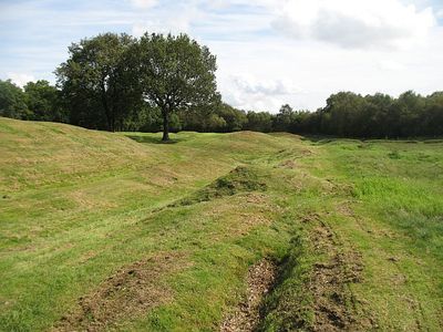
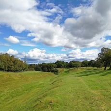
Rough Castle Fort, Roman fort near Bonnybridge, Scotland

Description

Rough Castle is a Roman fort positioned along the Antonine Wall, the empire's most northerly defensive line in Britain. The remains of barracks, administrative buildings, and storage structures are still visible, showing how the garrison was laid out nearly 2,000 years ago.

History

The site was built around 142 CE as part of the Roman frontier expansion under Antoninus Pius. The garrison was eventually abandoned as Rome adjusted its military strategy and moved the border further south.

Culture

The fort functioned as a Roman military outpost marking the empire's reach into northern Britain. You can walk around the remains and see where soldiers were housed, where commanders made decisions, and where supplies were stored.

Practical

The site is open year-round and free to visit, with clear walking paths throughout the grounds. Wear sturdy shoes as the terrain can be muddy or uneven depending on recent weather.

Did you know?

The northern entrance still shows shallow pits where Roman soldiers embedded sharpened stakes as a defensive trap. This detail reveals how frontier forces used simple but effective tactics to protect against attacks.

Location
Part of
Antonine Wall, Rough Castle fort, annexe and Military Way
GPS coordinates
55.99780,-3.85600
Latest update
December 8, 2025 19:58

AroundUs brings together thousands of curated places, local tips, and hidden gems, enriched daily by 60,000 contributors worldwide. Discover all places nearby (Falkirk).

Around this place
Falkirk Wheel
United Kingdom

Falkirk Wheel

934 m
Ochilview Park
United Kingdom

Ochilview Park

4.3 km
Torwood Castle
United Kingdom

Torwood Castle

4.6 km
Falkirk Old Parish Church
United Kingdom

Falkirk Old Parish Church

4.4 km
Falkirk Steeple
United Kingdom

Falkirk Steeple

4.5 km
Falkirk Library
United Kingdom

Falkirk Library

4.2 km
Denny Town House
United Kingdom

Denny Town House

3.9 km
St Mary of the Angels, Camelon
United Kingdom

St Mary of the Angels, Camelon

2.2 km
Larbert Old Church, Churchyard With James Bruce Monument
United Kingdom

Larbert Old Church, Churchyard With James Bruce Monument

2.6 km
Larbert Viaduct
United Kingdom

Larbert Viaduct

2.6 km
Larbert Old Church
United Kingdom

Larbert Old Church

2.7 km
ABC Falkirk
United Kingdom

ABC Falkirk

4.5 km
Stenhousemuir, Kirk Avenue, Larbert East Church And Hall
United Kingdom

Stenhousemuir, Kirk Avenue, Larbert East Church And Hall

4.1 km
Falkirk, Cochrane Avenue, St Modan's Church
United Kingdom

Falkirk, Cochrane Avenue, St Modan's Church

4.4 km
Lloyds Tsb Scotland, High Street, Falkirk
United Kingdom

Lloyds Tsb Scotland, High Street, Falkirk

4.5 km
Larbert, Main Street, Dobbie Hall
United Kingdom

Larbert, Main Street, Dobbie Hall

3.6 km
Old Bridge, Larbert
United Kingdom

Old Bridge, Larbert

2.5 km
Bainsford, Carron River, Carron Railway Bridge
United Kingdom

Bainsford, Carron River, Carron Railway Bridge

4.4 km
Dunipace Bridge
United Kingdom

Dunipace Bridge

2 km
Grahamston Ironworks, Falkirk
United Kingdom

Grahamston Ironworks, Falkirk

4.4 km
Carron, River Carron, Weir
United Kingdom

Carron, River Carron, Weir

4.3 km
Falkirk, Cow Wynd, The Tattie Kirk
United Kingdom

Falkirk, Cow Wynd, The Tattie Kirk

4.6 km
Antonine Wall, 495m WSW and 125m SE of Bonnyside House
United Kingdom

Antonine Wall, 495m WSW and 125m SE of Bonnyside House

1.1 km
Larbert bridge
United Kingdom

Larbert bridge

2.5 km
Larbert, Main Street, Larbert Station, War Memorial
United Kingdom

Larbert, Main Street, Larbert Station, War Memorial

3.2 km
Falkirk, 147-149 High Street
United Kingdom

Falkirk, 147-149 High Street

4.5 km
Lodge, Royal Scottish National Hospital, Bellsdyke Road, Larbert
United Kingdom

Lodge, Royal Scottish National Hospital, Bellsdyke Road, Larbert

4 km
Stenhousemuir, 86 Burnhead Road, Falkirk Tryst Golf Course, War Memorial
United Kingdom

Stenhousemuir, 86 Burnhead Road, Falkirk Tryst Golf Course, War Memorial

3.8 km
Show the full map
« Rough Castle Fort - Roman fort near Bonnybridge, Scotland » is provided by Around Us (aroundus.com). Images and texts are derived from Wikimedia project under a Creative Commons license. You are allowed to copy, distribute, and modify copies of this page, under the conditions set by the license, as long as this note is clearly visible.

Discover hidden gems everywhere you go!

From secret cafés to breathtaking viewpoints, skip the crowded tourist spots and find places that match your style. Our app makes it easy with voice search, smart filtering, route optimization, and insider tips from travelers worldwide. Download now for the complete mobile experience.

Around Us App Screenshot

A unique approach to discovering new places

Le Figaro

All the places worth exploring

France Info

A tailor-made excursion in just a few clicks

20 Minutes

Around Us
Travel Guide & Maps
Download

Send to your phone

QR Code
1

Open the camera app on your mobile.

2

Point at the QR code with your camera. A notification will appear.

3

Tap the notification to open the link.