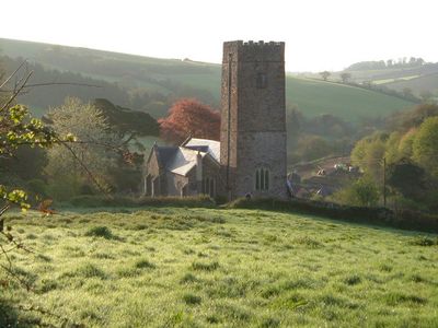
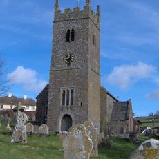
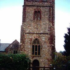
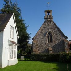
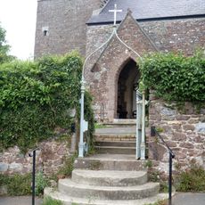
Parish Church of St Nectan, Medieval church in Ashcombe, England
The Parish Church of St Nectan exhibits medieval architectural elements with intricate stonework and a traditional English ecclesiastical design pattern.
Founded in 1250, the church stands as a Grade I listed building, representing centuries of religious continuity in the Devon region.
The structure maintains its position as a central gathering point for religious ceremonies and community events in the Ashcombe village.
Located at coordinates 50.6056, -3.53862, the church requires specific permissions for any modifications due to its protected heritage status.
The church holds a dual-language designation, recognized in Welsh as Eglwys y Plwyf, Sant Neithon, extending its cultural reach beyond Devon.
Location: Ashcombe
Inception: 13 century
GPS coordinates: 50.60560,-3.53862
Latest update: March 27, 2025 11:45
Devon combines historical sites and natural landscapes across a region in southwest England. The area extends from moorlands in Dartmoor National Park to cliffs along the Bristol Channel and English Channel coasts. Visitors find Norman castle ruins like Totnes Castle and Okehampton Castle, Georgian manor houses such as Saltram House, medieval villages, and monastery sites like Buckland Abbey. The landscape appears in forms of granite formations, waterfalls, remote beaches, and ancient woodlands. Places include Wistman's Wood with its gnarled oak trees, the rock formations at Valley of the Rocks near Lynton, the historic fishing village of Clovelly with its steep streets, and the sandy beaches at Bantham and Mothercombe. Speke's Mill Mouth Waterfall drops directly into the sea, while Blackchurch Rock stands as a coastal formation. Gardens like RHS Garden Rosemoor display botanical collections, and industrial sites such as the water-powered Finch Foundry or the Dartmouth Steam Railway document past working environments. Beer Quarry Caves offer views into historic underground stone quarrying.
Mamhead House
2.4 km
Castle Dyke
2.7 km
Ideford Common
1.6 km
Church of St Mary
2.8 km
Church of St Thomas
2.3 km
Chapel Of St John The Evangelist
2.7 km
Ashcombe War Memorial
1.7 km
Stable Yard And Service Buildings North West Of Dawlish College (Mamhead House)
2.4 km
The Obelisk
1.8 km
Road Bridge Over Dawlish Water
125 m
Broomhouse Farmhouse
2 km
The Old Rectory
69 m
Court Farmhouse
153 m
K6 Telephone Kiosk
2.9 km
Kitchen Garden Walls At Brinshill To The North, West And North West
2.8 km
Longbarn
2.9 km
4 Ranges Of Fambuildings At Home Farm
2.9 km
Terrace Wall To Terrace South Of Return Of The Palm House And Brinshill
2.8 km
Dawlish Lodge
2.1 km
Lychgate to Chapel of St John the Evangelist
2.7 km
The Old Mill
2.8 km
Mamhead Park
2.4 km
Langdon Barton
2 km
Lower Dunscombe Farmhouse
2.7 km
Churchyard Gate
2.8 km
Milestone, 200m S of Mamhead jct just S of sign to Ashcombe cottages and activities on N-bound carriageway
1.2 km
Milestone, Colley Lane, 50m S of Ashcombe small roundabout, beside Mamhead jct with A380
903 m
Milestone, 250m N of Mamhead Cross
1.6 kmReviews
Visited this place? Tap the stars to rate it and share your experience / photos with the community! Try now! You can cancel it anytime.
Discover hidden gems everywhere you go!
From secret cafés to breathtaking viewpoints, skip the crowded tourist spots and find places that match your style. Our app makes it easy with voice search, smart filtering, route optimization, and insider tips from travelers worldwide. Download now for the complete mobile experience.
A unique approach to discovering new places❞
— Le Figaro
All the places worth exploring❞
— France Info
A tailor-made excursion in just a few clicks❞
— 20 Minutes