Fortifications of Klundert, Military fortification in Moerdijk, Netherlands.
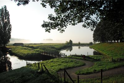
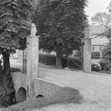
The Fortifications of Klundert comprise a star-shaped fortified settlement with moats, canals, and bastions creating a defensive perimeter around the village. The system fully encloses the town with waterways that served both as military protection and flood management in this low-lying area.
Built in 1581, the fortifications served as a crucial defense line during the Eighty Years' War against Spanish invasion. The strategic position protected the region throughout several conflicts and military campaigns.
The Flax and Sugar Museum within the fortified area displays the region's industrial and agricultural heritage. The exhibits reveal how these industries shaped the town's development and daily life.
Visitors can walk or cycle along designated paths around the moats and through the fortified area to explore the layout. Information boards along the way explain the military engineering and architectural features visible throughout the site.
The water system was not merely a defensive barrier but also an ingenious solution for managing flood risks in this flat terrain. This combination of military planning with practical flood control makes the fortification a remarkable example of dual-purpose engineering.
Location: Moerdijk
Address: Vestingwerken
GPS coordinates: 51.66056,4.53996
Latest update: December 14, 2025 18:44
Stadhuis Klundert
650 m
Sint-Catharinakerk, Zevenbergen
5 km
Sint-Bartholomeuskerk
5 km
Molen Fleur
4.7 km
Fort Bovensluis
4.6 km
Johannes de Doperkerk, Klundert
408 m
Nieuwe watertoren
4.3 km
Sint-Jozefkerk
2.1 km
Noordhaven 46, Zevenbergen
4.8 km
Kerkstraat 23, Zevenbergen
5 km
Molenstraat 36, Zevenbergen
4.8 km
Poortje bij Noordhaven 102, Zevenbergen
4.8 km
Poortpalen bij de boerderij 'Leeuwenstee'
3.9 km
Herenhuis met toegangshek
5.1 km
Molenstraat 12
4.9 km
Boerderij waarvan alleen de afzonderlijke woning van belang is, met zadeldak tussen zijtopgevels, in de gevel nog sporen van de oorspronkelijke vensters met korfbogen waarin natuursteenblokjes
5 km
Stationsstraat 1, Zevenbergen
5 km
Boerderij met afzonderlijk woonhuis onder zadeldak tussen topgevels
4.9 km
Complex Hopmansstraat
2.2 km
Dubbel woonhuis met tuinmuur en hek
5 km
Boerderijcomplex aan de tonsedijk, de westelijke afsluiting van de in 1558 ingedijkte nieuwe fijnaartse polder
3 km
Kerkring 21, Klundert
660 m
Zuidhaven 17, Zevenbergen
5 km
Huis op L-vormige plattegrond met topgevel aan de linkervleugel, wolfdak op de rechtervleugel; met riet gedekt; de gevels geelwit gesausd; achtdelige schuiframen.
4.9 km
Huis onder schilddak en met empire lijstgevel, gepleisterd, waarin door pilasters omlijste ingang, kroonlijst op voluutvormige consoles en versierd met guirlandes
666 m
Toegangshek Nederlands Hervormde Kerk
633 m
Woonhuis, opgetrokken in gele steen met witgeschilderde voorgevel
4.5 km
Boerendijk 15, Fijnaart
4.3 kmVisited this place? Tap the stars to rate it and share your experience / photos with the community! Try now! You can cancel it anytime.
Discover hidden gems everywhere you go!
From secret cafés to breathtaking viewpoints, skip the crowded tourist spots and find places that match your style. Our app makes it easy with voice search, smart filtering, route optimization, and insider tips from travelers worldwide. Download now for the complete mobile experience.
A unique approach to discovering new places❞
— Le Figaro
All the places worth exploring❞
— France Info
A tailor-made excursion in just a few clicks❞
— 20 Minutes