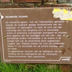
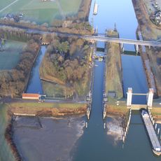
Mookerschans, Military fortification in Mook, Netherlands.
Mookerschans is a military fortification in Mook with a square layout measuring approximately 70 by 70 meters, fitted with complete bastions on the north side and half bastions on the south side. The structure is surrounded by a moat and constructed with earthen walls that reinforced its defensive capability.
The structure was built in the second half of the 17th century as a defensive installation along the regional border between the Dutch provinces of Gelderland and Limburg. It was part of a broader fortification system that secured this border region during the early modern period.
The fortification displays Dutch military engineering with its moat and earthen walls, now protected as a national monument. Visitors can explore the defensive layout and understand how border defense worked in that era.
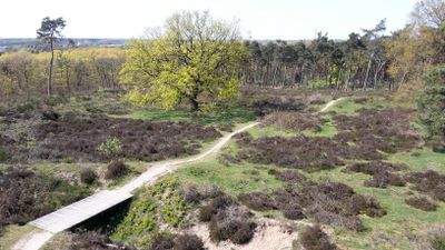
The fortification sits near the Mookerheide nature reserve and is accessible year-round through marked walking paths that wind around the site. Visitors should wear sturdy shoes, as the terrain is uneven and can be slippery when wet, especially near the moat.
An original bridge still crosses the moat today, allowing visitors to use the same access point that soldiers once did. This surviving structure demonstrates the practical ingenuity of 17th-century fortification design.
Location: Mook en Middelaar
Address: Mooker schans
GPS coordinates: 51.75853,5.88390
Latest update: December 14, 2025 18:47
Jachtslot de Mookerheide
1.3 km
Sluiscomplex Heumen
2.5 km
Heumense schans
718 m
Mook railway bridge
970 m
Nederlands Hervormde Kerk, Heumen
2.9 km
Sint-Antonius Abtkerk
916 m
Onze-Lieve-Vrouw van Zeven Smartenkerk
1.1 km
Monument voor het kunstenaarsverzet
821 m
Onze-Lieve-Vrouw van de Dwaallichtjeskapel
1.2 km
Molen van Linden
2.5 km
Memorial to the Dutch Soldiers
1.1 km
Kruiswegpark Katwijk, North Brabant
1.2 km
Sluiscomplex Heumen
2.5 km
Sint-Martinuskerk
1.2 km
Raadhuis
1.6 km
Rijksweg 208, Heumen
2 km
Casemates in Cuijk
1.1 km
Monument langs Klein Amerika
2.9 km
Mariamonument 1940-1945
3 km
Bergzicht: Voormalige bierbrouwerij annex mouterij
1.6 km
Bergzicht: voormalig koetshuis
1.6 km
Twaalf kazematten
1.3 km
Natuurstenen grafkruis op het terrein van de Herv. Kerk
2.9 km
Toren der Nederlands Hervormde Kerk
2.9 km
Boerderij met woongedeelte dat dwars voor de stal is gebouwd en een rieten zadeldak tussen puntgevels met vlechtingen draagt. Vensters met luiken en zesruitsschuiframen.
1.8 km
School met bovenmeesterhuis
1.6 km
Lourdesgrot
1.2 km
Monument voor Nederlandse Militairen
2.5 kmVisited this place? Tap the stars to rate it and share your experience / photos with the community! Try now! You can cancel it anytime.
Discover hidden gems everywhere you go!
From secret cafés to breathtaking viewpoints, skip the crowded tourist spots and find places that match your style. Our app makes it easy with voice search, smart filtering, route optimization, and insider tips from travelers worldwide. Download now for the complete mobile experience.
A unique approach to discovering new places❞
— Le Figaro
All the places worth exploring❞
— France Info
A tailor-made excursion in just a few clicks❞
— 20 Minutes