Enable Location

We need your location to show you interesting places around you

Discover nearby places

Find interesting locations and hidden gems around you

Precise directions

Get accurate directions and distances to places

Your location is never shared with other users. It's only used when you tap the location button.

Tamka Street

Log in to your account

Start exploring — it's free

Trusted by 62,057 travelers worldwide

Continue with Google
Continue with Apple
or

We will send you a code to connect

By continuing, you accept our Terms and Conditions and our Privacy Policy

Check your inbox

We've sent a pincode in your inbox. Please enter the code below.

Tamka Street

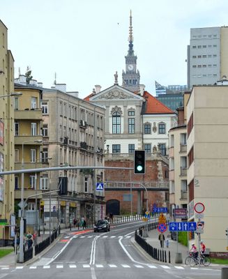
Tamka Street, Historical street in Powiśle district, Warsaw, Poland.

Tamka Street is a thoroughfare in central Warsaw that runs downhill from Świętokrzyska Street toward the Vistula River. It terminates at Świętokrzyski Bridge, linking the heart of the city to the riverbank through a gentle slope.

The street takes its name from a small dam that once controlled water flow in a stream running through this area. As the city grew, the stream disappeared into the urban landscape, but the name persisted as a memory of this waterway.

The Vistula River's presence shaped how this neighborhood developed and how people moved through it for centuries. You can still sense this connection when you walk downhill and notice how buildings face toward the water.

The street slopes gently downward and is easy to walk, especially starting from central Świętokrzyska Street. You will find good public transport connections in this central district, making it simple to reach or leave the area.

The street name is a faded echo of a geographical feature that vanished from the city long ago. This hidden link between an old name and a lost landscape tells a quiet story of urban transformation.

The community of curious travelers

AroundUs brings together thousands of curated places, local tips, and hidden gems, enriched daily by 60,000 contributors worldwide.

Start exploring
Location
Location
Shares border with
Wybrzeże Kościuszkowskie Street, Elektryczna Street, Dobra Street, Cicha Street, Mikołaja Kopernika Street
Address
Tamka
GPS coordinates
52.23758,21.02681
Latest update
December 9, 2025 18:43
« Tamka Street - Historical street in Powiśle district, Warsaw, Poland » is provided by Around Us (aroundus.com). Images and texts are derived from Wikimedia project under a Creative Commons license. You are allowed to copy, distribute, and modify copies of this page, under the conditions set by the license, as long as this note is clearly visible.

Discover hidden gems everywhere you go!

From secret cafés to breathtaking viewpoints, skip the crowded tourist spots and find places that match your style. Our app makes it easy with voice search, smart filtering, route optimization, and insider tips from travelers worldwide. Download now for the complete mobile experience.

Around Us App Screenshot

A unique approach to discovering new places

Le Figaro

All the places worth exploring

France Info

A tailor-made excursion in just a few clicks

20 Minutes

Around Us
Travel Guide & Maps
Download

Send to your phone

QR Code
1

Open the camera app on your mobile.

2

Point at the QR code with your camera. A notification will appear.

3

Tap the notification to open the link.