Trollhättan 64:1, hällristning i Västergötland
Location: Trollhättan Municipality
GPS coordinates: 58.26447,12.28945
Latest update: November 22, 2025 18:54

Saab Car Museum
1.1 km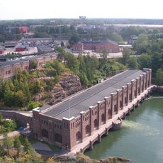
Olidan Hydroelectric Power Station
1.5 km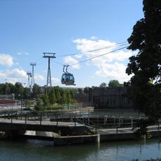
Innovatum Science Center
1.1 km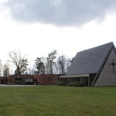
Lextorpskyrkan
392 m
Trollhättans missionskyrka
1.6 km
Ek på fastigheterna Pärlemorfjärilen 1 och 2
427 m
Starkodders sten
947 m
Trollhättan 181:1
444 m
Gärdhem 75:2
918 m
Trollhättan 63:1
386 m
Trollhättan 82:1
434 m
Trollhättan 91:1
1.4 km
Nohabs gamla smedja
1.2 km
Gärdhem 75:1
925 m
Lextorpskyrkan
389 m
IF Metall Verkstadsklubb Innovatum
1.2 km
Work of art
1.2 km
Arkiv
1.7 km
Albino Aid
1.1 km
Bench, scenic viewpoint
1.7 km
Scenic viewpoint
1.7 km
Scenic viewpoint
1.7 km
Kopparklinten
1.7 km
Scenic viewpoint
1.7 km
Scenic viewpoint
1.7 km
Bench, scenic viewpoint
1.7 km
Bench, scenic viewpoint
1.6 km
Scenic viewpoint
1.6 kmReviews
Visited this place? Tap the stars to rate it and share your experience / photos with the community! Try now! You can cancel it anytime.
Discover hidden gems everywhere you go!
From secret cafés to breathtaking viewpoints, skip the crowded tourist spots and find places that match your style. Our app makes it easy with voice search, smart filtering, route optimization, and insider tips from travelers worldwide. Download now for the complete mobile experience.

A unique approach to discovering new places❞
— Le Figaro
All the places worth exploring❞
— France Info
A tailor-made excursion in just a few clicks❞
— 20 Minutes