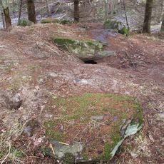
Bokenäs 82:1, röse i Bohuslän
Location: Uddevalla Municipality
GPS coordinates: 58.28013,11.52676
Latest update: November 23, 2025 05:16
Ganggrab von Berg
1.3 km
Hultås
1.2 km
Bokenäs 28:1
1.5 km
Axel Tordssons grav
1.1 km
Bokenäs 89:1
1.3 km
Bokenäs 43:1
1.3 km
Bokenäs 90:1
1.3 km
Bokenäs 42:2
1.4 km
Bokenäs 440:1
1.7 km
Borrås
395 m
Bokenäs 440:3
1.7 km
Bokenäs 42:1
1.4 km
Bokenäs 75:1
429 m
Bokenäs 83:2
349 m
Bokenäs 77:1
1.6 km
Bokenäs 91:1
1 km
Bokenäs 76:1
780 m
Bokenäs 459
1.6 km
Bokenäs 89:2
1.3 km
Bokenäs 457
1.6 km
Bokenäs 244:1
1.5 km
Bokenäs 439:2
1.7 km
Bokenäs 440:2
1.7 km
Bokenäs 80:1
1.3 km
Kung Stompes grav
1.3 km
Bokenäs 366:1
1.1 km
Dragsmark 21:1
905 m
Dragsmark 17:1
611 mReviews
Visited this place? Tap the stars to rate it and share your experience / photos with the community! Try now! You can cancel it anytime.
Discover hidden gems everywhere you go!
From secret cafés to breathtaking viewpoints, skip the crowded tourist spots and find places that match your style. Our app makes it easy with voice search, smart filtering, route optimization, and insider tips from travelers worldwide. Download now for the complete mobile experience.

A unique approach to discovering new places❞
— Le Figaro
All the places worth exploring❞
— France Info
A tailor-made excursion in just a few clicks❞
— 20 Minutes