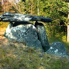
Stala 78:1, röse i Bohuslän
Location: Orust Municipality
GPS coordinates: 58.14966,11.62800
Latest update: November 22, 2025 18:13
Haga dolmen
1.4 km
Stala 68:1
955 m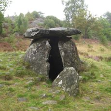
Haga dösen
1.4 km
Stala 79:1
585 m
Stala 71:1
1.4 km
Stala 91:1
975 m
Stala 66:1
1 km
Stala 166:2
1.5 km
Tegneby 147:1
897 m
Stala 172:3
1.2 km
Stala 90:1
679 m
Stala 172:1
1.2 km
Tegneby 393:1
1.4 km
Stala 80:1
902 m
Stala 76:1
687 m
Stala 67:1
1.3 km
Stala 168:1
1.3 km
Stala 167:2
1.4 km
Stala 75:1
865 m
Stala 171:1
1.1 km
Stala 88:1
915 m
Tegneby 127:1
603 m
Stala 166:1
1.4 km
Tegneby 146:1
1.1 km
Stala 172:2
1.2 km
Stala 167:1
1.4 km
Stala 383
992 m
Tegneby 130:1
1.1 kmReviews
Visited this place? Tap the stars to rate it and share your experience / photos with the community! Try now! You can cancel it anytime.
Discover hidden gems everywhere you go!
From secret cafés to breathtaking viewpoints, skip the crowded tourist spots and find places that match your style. Our app makes it easy with voice search, smart filtering, route optimization, and insider tips from travelers worldwide. Download now for the complete mobile experience.

A unique approach to discovering new places❞
— Le Figaro
All the places worth exploring❞
— France Info
A tailor-made excursion in just a few clicks❞
— 20 Minutes