Tegneby 141:1, hällristning i Bohuslän
Location: Orust Municipality
GPS coordinates: 58.14355,11.59936
Latest update: November 17, 2025 04:48
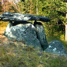
Haga dolmen
811 m
Tegneby 118:1
724 m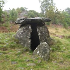
Haga dösen
812 m
Tegneby 120:1
438 m
Tegneby 135:1
766 m
Tegneby 131:1
589 m
Tegneby 124:2
451 m
Tegneby 115:1
798 m
Tegneby 115:2
779 m
Tegneby 134:1
813 m
Tegneby 121:1
385 m
Tegneby 124:3
436 m
Tegneby 124:4
413 m
Tegneby 115:3
811 m
Tegneby 139:1
167 m
Tegneby 124:1
445 m
Tegneby 183:1
186 m
Tegneby 117:1
717 m
Tegneby 136:2
442 m
Tegneby 116:1
705 m
Tegneby 137:1
171 m
Tegneby 121:2
369 m
Tegneby 126:1
715 m
Tegneby 138:1
160 m
Tegneby 122:1
571 m
Tegneby 140:1
365 m
Tegneby 141:2
45 m
Tegneby 141:4
12 mReviews
Visited this place? Tap the stars to rate it and share your experience / photos with the community! Try now! You can cancel it anytime.
Discover hidden gems everywhere you go!
From secret cafés to breathtaking viewpoints, skip the crowded tourist spots and find places that match your style. Our app makes it easy with voice search, smart filtering, route optimization, and insider tips from travelers worldwide. Download now for the complete mobile experience.

A unique approach to discovering new places❞
— Le Figaro
All the places worth exploring❞
— France Info
A tailor-made excursion in just a few clicks❞
— 20 Minutes