"Krigargrav", gravfält i Värmland (Ekshärad 5:1)
Location: Hagfors Municipality
GPS coordinates: 60.17171,13.51482
Latest update: November 6, 2025 00:52
Hagfors Observatory
10.9 km
Ginbergsängen
5.2 km
Ekshärad 6:1
820 m
Gammelsätern
10.5 km
Ekshärad 6:2
822 m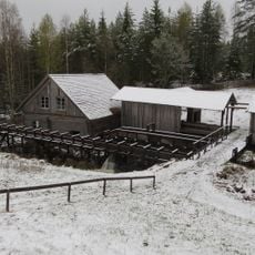
Hamra vadmalsstamp
11.1 km
Ekshärad 30:1
2.4 km
Brattsätern
10.8 km
Ekshärad 16:1
7.4 km
Kattsätern
9.2 km
Ekshärad 28:2
6.7 km
Ekshärad 28:1
6.8 km
Rensätern
10.1 km
Kartstenen
6.9 km
Ekshärad 1:1
1.9 km
Ekshärad 1:2
1.9 km
Ekshärad 2:1
2.5 km
Knobergsvallen
6.4 km
Vålesätern
9.7 km
Gammelsätern
10.1 km
Ekshärad 200:1
10.5 km
Ekshärad 14:2
7.1 km
Ekshärad 14:1
7.1 km
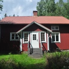
Ekshärads hembygdsgård
986 m
Hamra vadmalsstamp
11.1 km
Ekshärads kyrkstallar
935 m
Ekshärads hembygdsgård
997 m
Mini golf
1 kmReviews
Visited this place? Tap the stars to rate it and share your experience / photos with the community! Try now! You can cancel it anytime.
Discover hidden gems everywhere you go!
From secret cafés to breathtaking viewpoints, skip the crowded tourist spots and find places that match your style. Our app makes it easy with voice search, smart filtering, route optimization, and insider tips from travelers worldwide. Download now for the complete mobile experience.

A unique approach to discovering new places❞
— Le Figaro
All the places worth exploring❞
— France Info
A tailor-made excursion in just a few clicks❞
— 20 Minutes