Grundsunda 334:1, ristning, medeltid/historisk tid i Ångermanland
Location: Örnsköldsvik Municipality
GPS coordinates: 63.19093,19.03617
Latest update: November 4, 2025 10:12
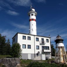
Skagsudde lighthouse
1.1 km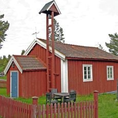
Skeppsmalns kapell
934 m
Gråklubben
637 m
Skags Flasor
3.1 km
Sundklubben
5.6 km
Ällöviken lighthouse
2.5 km
Skaghällan
2 km
Råskärsön lighthouse
6.4 km
Grundsunda 335:1
1.8 km
Skede kapell
6.8 km
Skeppsmalens fyr
1.3 km
Grundsunda 131:2
6.5 km
Grundsunda 135:2
7.2 km
Grundsunda 77:2
2.8 km
Grundsunda 323:1
2.9 km
Grundsunda 135:1
7.2 km
Grundsunda 134:2
7.2 km
Grundsunda 131:1
6.5 km
Grundsunda 130:1
7 km
Grundsunda 135:3
7.2 km
Grundsunda 77:1
2.8 km
Grundsunda 134:1
7.2 km
Jättegryta
6.9 km
Labyrint
1.8 km
Labyrint
1.9 km
Scenic viewpoint
2 km
Scenic viewpoint
6.4 km
Scenic viewpoint
1.5 kmReviews
Visited this place? Tap the stars to rate it and share your experience / photos with the community! Try now! You can cancel it anytime.
Discover hidden gems everywhere you go!
From secret cafés to breathtaking viewpoints, skip the crowded tourist spots and find places that match your style. Our app makes it easy with voice search, smart filtering, route optimization, and insider tips from travelers worldwide. Download now for the complete mobile experience.

A unique approach to discovering new places❞
— Le Figaro
All the places worth exploring❞
— France Info
A tailor-made excursion in just a few clicks❞
— 20 Minutes