Enable Location

We need your location to show you interesting places around you

Discover nearby places

Find interesting locations and hidden gems around you

Precise directions

Get accurate directions and distances to places

Your location is never shared with other users. It's only used when you tap the location button.

Flatside Wilderness

Log in to your account

Start exploring — it's free

Trusted by 62,806 travelers worldwide

Continue with Google
Continue with Apple
or

We will send you a code to connect

By continuing, you accept our Terms and Conditions and our Privacy Policy

Check your inbox

We've sent a pincode in your inbox. Please enter the code below.

Flatside Wilderness

Flatside Wilderness, US Wilderness Area in Ouachita National Forest, Arkansas

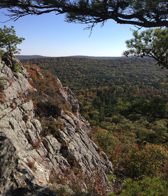
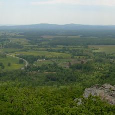
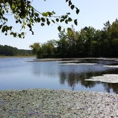
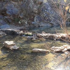
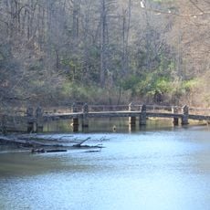
Flatside Wilderness is a protected area in the Ouachita National Forest spanning about 9,500 acres of dense forests, rocky outcrops, and multiple mountain peaks rising to roughly 1,800 feet. Small streams run through the terrain, creating a diverse landscape for hikers.

The area received official protection status in 1984 through federal legislation designating wilderness lands in Arkansas. An additional section was added later to expand the protected territory.

The land is valued for its untouched natural state, where visitors experience forests and mountains without structures or motorized equipment. This wilderness offers people a place to step away from modern life and connect with the forest on its own terms.

Access the area through Forest Service roads from the main highway, with parking available near the main trailhead. Spring through fall offers the best hiking conditions, when trails are dry and most accessible.

A long-distance hiking route runs through the area connecting multiple regions together. This trail passes through changing terrain and reveals interesting geological formations that most visitors might overlook.

The community of curious travelers

AroundUs brings together thousands of curated places, local tips, and hidden gems, enriched daily by 60,000 contributors worldwide.

Start exploring
Location
GPS coordinates
34.85970,-92.94750
Latest update
December 12, 2025 12:02
Around this place
Petit Jean State Park
United States of America

Petit Jean State Park

28.5 km
South Fork Bridge
United States of America

South Fork Bridge

28.7 km
CCC architecture of Petit Jean State Park
United States of America

CCC architecture of Petit Jean State Park

29.9 km
Petit Jean State Park-Lake Bailey-Roosevelt Lake Historic District
United States of America

Petit Jean State Park-Lake Bailey-Roosevelt Lake Historic District

30.1 km
Fourche LaFave River Bridge
United States of America

Fourche LaFave River Bridge

21.3 km
Cedar Creek Bridge
United States of America

Cedar Creek Bridge

30 km
Wallace Bridge
United States of America

Wallace Bridge

13 km
Iron Springs Recreation Area
United States of America

Iron Springs Recreation Area

15.6 km
Pleasant Hill Methodist Church
United States of America

Pleasant Hill Methodist Church

35.4 km
Ward's Crossing Bridge
United States of America

Ward's Crossing Bridge

36 km
South Fourche LaFave River Bridge
United States of America

South Fourche LaFave River Bridge

15 km
Cox House
United States of America

Cox House

36.9 km
Mountain View Farm
United States of America

Mountain View Farm

34.4 km
Camp House
United States of America

Camp House

13.1 km
Houston Methodist Episcopal Church, South
United States of America

Houston Methodist Episcopal Church, South

30.1 km
Peter Dierks Joers House
United States of America

Peter Dierks Joers House

35.7 km
Kimball House
United States of America

Kimball House

36.2 km
Camp Ouachita Girl Scout Camp Historic District
United States of America

Camp Ouachita Girl Scout Camp Historic District

11.6 km
Fordyce-Ricks House Historic District
United States of America

Fordyce-Ricks House Historic District

36.8 km
Trinity Lutheran Church
United States of America

Trinity Lutheran Church

30.5 km
Perry County Courthouse
United States of America

Perry County Courthouse

21 km
Petit Jean River Bridge
United States of America

Petit Jean River Bridge

36.2 km
C.L. Sailor House
United States of America

C.L. Sailor House

32.5 km
Perryville American Legion Building
United States of America

Perryville American Legion Building

20.9 km
Hawks Schoolhouse
United States of America

Hawks Schoolhouse

23.8 km
Bigelow Methodist Episcopal Church, South
United States of America

Bigelow Methodist Episcopal Church, South

32.9 km
Perryville Commercial Historic District
United States of America

Perryville Commercial Historic District

20.9 km
Evans-Neuhart House
United States of America

Evans-Neuhart House

34.7 km
Show the full map
« Flatside Wilderness - US Wilderness Area in Ouachita National Forest, Arkansas » is provided by Around Us (aroundus.com). Images and texts are derived from Wikimedia project under a Creative Commons license. You are allowed to copy, distribute, and modify copies of this page, under the conditions set by the license, as long as this note is clearly visible.

Discover hidden gems everywhere you go!

From secret cafés to breathtaking viewpoints, skip the crowded tourist spots and find places that match your style. Our app makes it easy with voice search, smart filtering, route optimization, and insider tips from travelers worldwide. Download now for the complete mobile experience.

Around Us App Screenshot

A unique approach to discovering new places

Le Figaro

All the places worth exploring

France Info

A tailor-made excursion in just a few clicks

20 Minutes

Around Us
Travel Guide & Maps
Download

Send to your phone

QR Code
1

Open the camera app on your mobile.

2

Point at the QR code with your camera. A notification will appear.

3

Tap the notification to open the link.