Gates Farm Covered Bridge

Log in to your account

AroundUs is a community-driven map of interesting places, built by curious explorers like you. It grows with every review, story, and photo you share.
Connect to save your favorite spots, contribute locations, and create personalized routes.
By continuing, you accept our Terms and Conditions and our Privacy Policy
Add to collection
Map
Suggest a change
Share

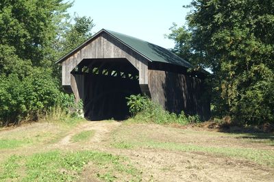
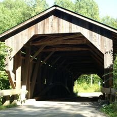
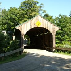
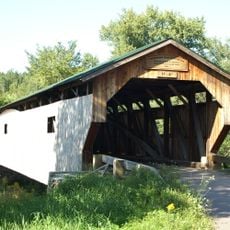
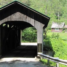
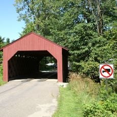
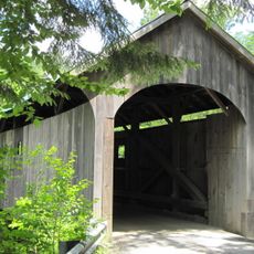
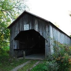
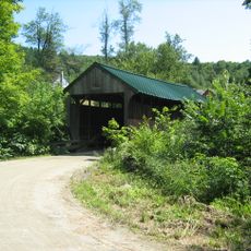
Gates Farm Covered Bridge, Covered bridge in Cambridge, US.

Gates Farm Covered Bridge is a covered bridge in Cambridge that crosses the Seymour River with a span of approximately 82.5 feet. It features vertical wood siding, a gabled metal roof, and stands on concrete abutments on either side of the water.

Built in 1897, it represents the final stages of covered bridge construction in Vermont using the Burr arch system. The structure was relocated to its current location in 1950 when changes in the river channel made the original site unsuitable.

The bridge reflects Vermont's rural heritage and how communities incorporated river crossings into their farmland. Today it stands on private property as a historical marker of the practical engineering that connected agricultural areas.

Located on private farmland east of Cambridge village, access to the bridge depends on current farm operations and property conditions. Visitors should approach respectfully as it remains an active part of the farm and is not set up as a public attraction.

As one of the last bridges built with this specific design, it experienced a rare occurrence: its location changed because of natural river movement rather than human decision. This relocation highlights how powerful water can be in reshaping the landscape and forcing communities to adapt their infrastructure.

Location: Cambridge

Inception: 1897

GPS coordinates: 44.64572,-72.87227

Latest update: December 14, 2025 13:03

Photos
Hidden places in Vermont: granite quarries, covered bridges, historic villages

Vermont hides historic places away from main roads, often forgotten by hurried travelers. Here you find granite quarries still working or long abandoned, small rural schools from the 1800s where children learned together, wooden covered bridges, and waterfalls flowing through thick forests. Trails...

Around this place
Mount Mansfield
United States of America

Mount Mansfield

12.2 km
Long Trail
United States of America

Long Trail

13.4 km
Smugglers' Notch State Park
United States of America

Smugglers' Notch State Park

11.9 km
Mount Mansfield State Forest
United States of America

Mount Mansfield State Forest

17.7 km
Underhill State Park
United States of America

Underhill State Park

13.2 km
Grist Mill Covered Bridge
United States of America

Grist Mill Covered Bridge

3.9 km
Church Street Covered Bridge
United States of America

Church Street Covered Bridge

9.4 km
Poland Covered Bridge
United States of America

Poland Covered Bridge

4.6 km
Morgan Covered Bridge
United States of America

Morgan Covered Bridge

15.8 km
St. Thomas Church
United States of America

St. Thomas Church

15.6 km
Montgomery Covered Bridge
United States of America

Montgomery Covered Bridge

10.1 km
Cambridge Meetinghouse
United States of America

Cambridge Meetinghouse

3.2 km
Maple Street Covered Bridge
United States of America

Maple Street Covered Bridge

11.1 km
Power House Covered Bridge
United States of America

Power House Covered Bridge

16 km
Browns River Covered Bridge
United States of America

Browns River Covered Bridge

11.4 km
Mill Covered Bridge
United States of America

Mill Covered Bridge

15.1 km
East Fairfield Covered Bridge
United States of America

East Fairfield Covered Bridge

15.6 km
St. George's Catholic Church
United States of America

St. George's Catholic Church

16.1 km
Scribner Covered Bridge
United States of America

Scribner Covered Bridge

17.8 km
Jeffersonville Bridge
United States of America

Jeffersonville Bridge

3.3 km
Fletcher Union Church
United States of America

Fletcher Union Church

5.1 km
Waterman Covered Bridge
United States of America

Waterman Covered Bridge

15.4 km
Nye Block
United States of America

Nye Block

15.1 km
Jaynes Covered Bridge
United States of America

Jaynes Covered Bridge

11.8 km
Bridge 6
United States of America

Bridge 6

14.9 km
District No. 5 Schoolhouse
United States of America

District No. 5 Schoolhouse

15.3 km
Waterville Village Historic District
United States of America

Waterville Village Historic District

9.5 km
Jeffersonville Historic District
United States of America

Jeffersonville Historic District

3.5 km
Show the full map
Reviews

Visited this place? Tap the stars to rate it and share your experience / photos with the community! Try now! You can cancel it anytime.

« Gates Farm Covered Bridge - Covered bridge in Cambridge, US » is provided by Around Us (aroundus.com). Images and texts are derived from Wikimedia project under a Creative Commons license. You are allowed to copy, distribute, and modify copies of this page, under the conditions set by the license, as long as this note is clearly visible.

Discover hidden gems everywhere you go!

From secret cafés to breathtaking viewpoints, skip the crowded tourist spots and find places that match your style. Our app makes it easy with voice search, smart filtering, route optimization, and insider tips from travelers worldwide. Download now for the complete mobile experience.

Around Us App Screenshot

A unique approach to discovering new places

Le Figaro

All the places worth exploring

France Info

A tailor-made excursion in just a few clicks

20 Minutes