Enable Location

We need your location to show you interesting places around you

Discover nearby places

Find interesting locations and hidden gems around you

Precise directions

Get accurate directions and distances to places

Your location is never shared with other users. It's only used when you tap the location button.

Pill Hill, Rochester, Minnesota

Log in to your account

Start exploring — it's free

Trusted by 62,392 travelers worldwide

Continue with Google
Continue with Apple
or

We will send you a code to connect

By continuing, you accept our Terms and Conditions and our Privacy Policy

Check your inbox

We've sent a pincode in your inbox. Please enter the code below.

Pill Hill, Rochester, Minnesota, Historic residential district in Rochester, United States.

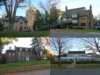
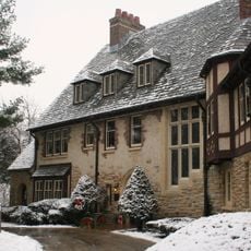
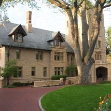
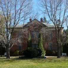
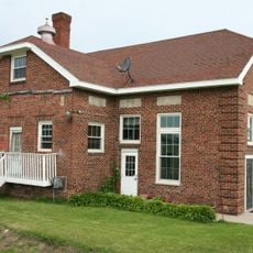
Pill Hill is a historic residential district in Rochester situated on elevated ground throughout the neighborhood. The area is characterized by substantial homes constructed from the early 1900s through the 1930s.

The neighborhood developed in the early 1900s as a residential area for doctors and professionals from two major medical institutions in the city. Its historical importance led to listing on the National Register of Historic Places in 1990.

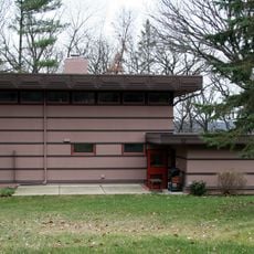
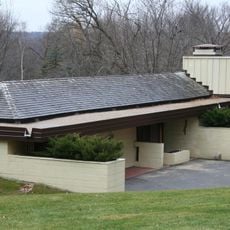
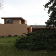
The neighborhood displays various architectural styles across its two-story homes, including Colonial Revival and Tudor Revival designs. These houses reflect the tastes and values of the families who made their lives here.

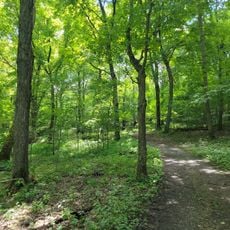
The district lies between 3rd and 9th Streets and 7th and 10th Avenues Southwest with convenient access to downtown. Visitors can walk through the area to view the homes and surrounding landscape.

Local architect Harold Crawford designed multiple houses in the area, blending traditional materials with forms that suited the preferences of the resident medical professionals. His work continues to shape the distinctive character of the neighborhood.

The community of curious travelers

AroundUs brings together thousands of curated places, local tips, and hidden gems, enriched daily by 60,000 contributors worldwide.

Start exploring
Location
GPS coordinates
44.01690,-92.47530
Latest update
December 12, 2025 17:43
Around this place
Plummer Building
United States of America

Plummer Building

943 m
Plummer House
United States of America

Plummer House

818 m
Gonda Building
United States of America

Gonda Building

976 m
United States of America

Mayo Civic Center

1.5 km
Century High School
United States of America

Century High School

5.4 km
Mayo Building
United States of America

Mayo Building

910 m
Guggenheim Building
United States of America

Guggenheim Building

800 m
Chateau Theatre
United States of America

Chateau Theatre

1.1 km
Oxbow Park and Zollman Zoo
United States of America

Oxbow Park and Zollman Zoo

15.9 km
James McBean Residence
United States of America

James McBean Residence

2.3 km
Thomas Keys Residence
United States of America

Thomas Keys Residence

1.4 km
Co-Cathedral of St. John the Evangelist
United States of America

Co-Cathedral of St. John the Evangelist

870 m
A. H. Bulbulian Residence
United States of America

A. H. Bulbulian Residence

1.4 km
Broadway Plaza
United States of America

Broadway Plaza

1.2 km
Dr. William J. Mayo House
United States of America

Dr. William J. Mayo House

421 m
Siebens Building
United States of America

Siebens Building

979 m
Avalon Music
United States of America

Avalon Music

1.4 km
Rochester Public Library
United States of America

Rochester Public Library

1.3 km
Opus Imaging Research Building
United States of America

Opus Imaging Research Building

621 m
Kasson Public School
United States of America

Kasson Public School

22.2 km
Rochester Art Center
United States of America

Rochester Art Center

1.4 km
George Stoppel Farmstead
United States of America

George Stoppel Farmstead

2.9 km
Ole Carlson House
United States of America

Ole Carlson House

19.1 km
Viola Cooperative Creamery
United States of America

Viola Cooperative Creamery

17.3 km
Kasson Municipal Building
United States of America

Kasson Municipal Building

22.1 km
Pleasant Grove Masonic Lodge
United States of America

Pleasant Grove Masonic Lodge

17.9 km
Spark
United States of America

Spark

1.5 km
Medical Pioneers of Minnesota Historical Marker
United States of America

Medical Pioneers of Minnesota Historical Marker

16.7 km
Show the full map
« Pill Hill, Rochester, Minnesota - Historic residential district in Rochester, United States » is provided by Around Us (aroundus.com). Images and texts are derived from Wikimedia project under a Creative Commons license. You are allowed to copy, distribute, and modify copies of this page, under the conditions set by the license, as long as this note is clearly visible.

Discover hidden gems everywhere you go!

From secret cafés to breathtaking viewpoints, skip the crowded tourist spots and find places that match your style. Our app makes it easy with voice search, smart filtering, route optimization, and insider tips from travelers worldwide. Download now for the complete mobile experience.

Around Us App Screenshot

A unique approach to discovering new places

Le Figaro

All the places worth exploring

France Info

A tailor-made excursion in just a few clicks

20 Minutes

Around Us
Travel Guide & Maps
Download

Send to your phone

QR Code
1

Open the camera app on your mobile.

2

Point at the QR code with your camera. A notification will appear.

3

Tap the notification to open the link.