Chest opened
+${chestReward.xp} XP
Explorer
NOUVEAU ×${chestReward.collectible.quantity}
tapez pour fermer
Chest locked

Open chests in the app

Around Us is built for your phone — chests unlock when you walk, explore and capture nearby places.

Enable Location

We need your location to show you interesting places around you

Discover nearby places

Find interesting locations and hidden gems around you

Precise directions

Get accurate directions and distances to places

Your location is never shared with other users. It's only used when you tap the location button.

Log in to your account

Start exploring — it's free

Trusted by 73,101 travelers worldwide

Continue with Google
Continue with Apple
or

We will send you a code to connect

By continuing, you accept our Terms and Conditions and our Privacy Policy

Check your inbox

We've sent a pincode in your inbox. Please enter the code below.

Roswell and Elizabeth Garst Farmstead Historic District
Discussion Reviews Photo
3.4k Popularity

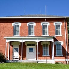
Roswell and Elizabeth Garst Farmstead Historic District, Historic district in Coon Rapids, Iowa.

The Farmstead is a residential and working complex with a 1.5-story farmhouse and eleven support buildings situated on agricultural land in Guthrie County. The structures demonstrate the infrastructure of a large-scale operation with storage buildings, work areas, and equipment stations that served different farming functions.

The farmstead was established in the early twentieth century and developed into a center for innovations in hybrid corn research. Work here influenced farming practices far beyond Iowa and attracted international attention.

The farm shows how family operations transformed through new growing methods and how these changes shaped daily life for residents. Visitors can still see today how traditional techniques were combined with new approaches.

The site is accessible by car and the buildings can be viewed from outside, with some interiors open to walk through. Comfortable shoes are recommended since the grounds are rolling and distances between structures require walking.

The farmstead received a high-profile Soviet visitor in 1959 who wanted to observe advanced growing methods firsthand. This encounter during the Cold War remains an unusual example of exchange during a period of significant political tension.

The community of curious travelers

AroundUs brings together thousands of curated places, local tips, and hidden gems, enriched daily by 60,000 contributors worldwide.

Start exploring
Location
GPS coordinates
41.85889,-94.67083
Latest update
December 12, 2025 07:58
Around this place
Springbrook State Park
United States of America

Springbrook State Park

19.8 km
Audubon County Court House
United States of America

Audubon County Court House

26.3 km
Guthrie County Courthouse
United States of America

Guthrie County Courthouse

24.5 km
United States of America

John Cretsinger House

6.3 km
United States of America

Holy Guardian Angels Church and Cemetery Historic District

25.8 km
United States of America

Robin Avenue Bridge

27.7 km
United States of America

Kittyhawk Avenue Bridge

26.7 km
United States of America

Quail Avenue Bridge

21.3 km
United States of America

Ross Grain Elevator

22.9 km
United States of America

Storm Creek Bridge 2

26.1 km
Audubon County Home Historic District
United States of America

Audubon County Home Historic District

27.7 km
United States of America

Christy Pond Park

2.1 km
United States of America

Hobart Wildlife Area

27.7 km
United States of America

Seeley Creek Timber

22.9 km
United States of America

Richey County Park

26.1 km
United States of America

Bennett County Park

26.8 km
United States of America

Rolling Hills Park

27.4 km
United States of America

Daniel Davis Timber

11.5 km
United States of America

Swan Lake State Park

24.8 km
Springbrook State Park, Civilian Conservation Corps Area
United States of America

Springbrook State Park, Civilian Conservation Corps Area

19.3 km
United States of America

Carroll City–Mount Olivet Cemetery

27 km
United States of America

Carroll Country Club

25.8 km
United States of America

Audubon Golf and Country Club

27.4 km
United States of America

Guthrie Center Golf Club

25.4 km
United States of America

Panorama West Golf Course

27.3 km
United States of America

Coon Rapids Country Club

709 m
United States of America

John James Audubon Statue

26.5 km
United States of America

Coon Rapids Sculpture Park

346 m
Show the full map
Reviews
Share your experience

No review yet

Discussions
Start a discussion...

No discussion yet

« Roswell and Elizabeth Garst Farmstead Historic District - Historic district in Coon Rapids, Iowa » is provided by Around Us (aroundus.com). Images and texts are derived from Wikimedia project under a Creative Commons license. You are allowed to copy, distribute, and modify copies of this page, under the conditions set by the license, as long as this note is clearly visible.

Discover hidden gems everywhere you go!

From secret cafés to breathtaking viewpoints, skip the crowded tourist spots and find places that match your style. Our app makes it easy with voice search, smart filtering, route optimization, and insider tips from travelers worldwide. Download now for the complete mobile experience.

Around Us App Screenshot

A unique approach to discovering new places

Le Figaro

All the places worth exploring

France Info

A tailor-made excursion in just a few clicks

20 Minutes

Around Us
Travel Guide & Maps
Download

Send to your phone

QR Code
1

Open the camera app on your mobile.

2

Point at the QR code with your camera. A notification will appear.

3

Tap the notification to open the link.