Enable Location

We need your location to show you interesting places around you

Discover nearby places

Find interesting locations and hidden gems around you

Precise directions

Get accurate directions and distances to places

Your location is never shared with other users. It's only used when you tap the location button.

Wertz's Covered Bridge

Log in to your account

Start exploring — it's free

Trusted by 61,901 travelers worldwide

Continue with Google
Continue with Apple
or

We will send you a code to connect

By continuing, you accept our Terms and Conditions and our Privacy Policy

Check your inbox

We've sent a pincode in your inbox. Please enter the code below.

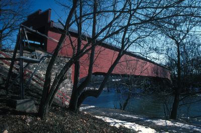
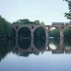
Wertz's Covered Bridge, Covered bridge in Berks County, United States.

Wertz's Covered Bridge is a wooden bridge painted red that spans across Tulpehocken Creek and connects Bern Township and Spring Township. The structure uses a special arch truss design to cover its long distance without support columns in the middle.

The bridge was built in 1867 near Wertz's Mill and served vehicles for more than 90 years. It lost its traffic role in 1959 when the Warren Street Bypass opened and diverted traffic to a new route.

The bridge marks the entrance to Berks County Heritage Center and shows how people in the 1800s built wooden structures with arch truss design. It represents the engineering knowledge and craftsmanship that was common in this region during that era.

You can reach the location at the Heritage Center grounds, which is open year-round and offers parking. It works best to visit the bridge along with the nearby museum to get a complete experience of the site.

The bridge is Pennsylvania's longest single-span wooden structure of its kind and attracts people interested in architecture who want to see how builders created such long spans without modern equipment. This technical achievement makes it a special example of 1800s engineering.

The community of curious travelers

AroundUs brings together thousands of curated places, local tips, and hidden gems, enriched daily by 60,000 contributors worldwide.

Start exploring
Location
Location
GPS coordinates
40.36861,-75.97889
Latest update
December 14, 2025 16:45
Around this place
Reading Public Museum
United States of America

Reading Public Museum

5.2 km
GoggleWorks
United States of America

GoggleWorks

4.9 km
Bethel A.M.E. Church
United States of America

Bethel A.M.E. Church

6.2 km
Gruber Wagon Works
United States of America

Gruber Wagon Works

229 m
Skew Arch Bridge
United States of America

Skew Arch Bridge

5.3 km
Reading Hardware Company
United States of America

Reading Hardware Company

6.5 km
Penn Street Bridge
United States of America

Penn Street Bridge

5.2 km
Frederick Lauer Monument
United States of America

Frederick Lauer Monument

6.6 km
Stirling
United States of America

Stirling

4.2 km
City Hall
United States of America

City Hall

5.9 km
Peter Wanner Mansion
United States of America

Peter Wanner Mansion

6.9 km
Peacock's Lock Viaduct
United States of America

Peacock's Lock Viaduct

5.3 km
Reading Knitting Mills
United States of America

Reading Knitting Mills

5.2 km
Metropolitan Edison Building
United States of America

Metropolitan Edison Building

5.5 km
Charles S. Foos Elementary School
United States of America

Charles S. Foos Elementary School

4.1 km
Red Men Hall
United States of America

Red Men Hall

5.8 km
Log House, Hiester House and Market Annex
United States of America

Log House, Hiester House and Market Annex

5.6 km
Wilhelm Mansion and Carriage House
United States of America

Wilhelm Mansion and Carriage House

4.7 km
Reading Hardware Company Butt Works
United States of America

Reading Hardware Company Butt Works

6.6 km
Hendel Brothers, Sons and Company Hat Factory
United States of America

Hendel Brothers, Sons and Company Hat Factory

6.5 km
Grimshaw Silk Mill
United States of America

Grimshaw Silk Mill

5.6 km
Rieser-Shoemaker Farm
United States of America

Rieser-Shoemaker Farm

6.9 km
Queen Anne Historic District
United States of America

Queen Anne Historic District

4.2 km
Reading Blue Mountain & Northern Railroad
United States of America

Reading Blue Mountain & Northern Railroad

4.2 km
Mid-Atlantic Air Museum
United States of America

Mid-Atlantic Air Museum

1.8 km
Old Dry Road
United States of America

Old Dry Road

6.8 km
Livingood House-Stryker Hospital
United States of America

Livingood House-Stryker Hospital

5.5 km
Meinig Glove Factory-E. Richard Meinig Co.
United States of America

Meinig Glove Factory-E. Richard Meinig Co.

4.4 km
Show the full map
« Wertz's Covered Bridge - Covered bridge in Berks County, United States » is provided by Around Us (aroundus.com). Images and texts are derived from Wikimedia project under a Creative Commons license. You are allowed to copy, distribute, and modify copies of this page, under the conditions set by the license, as long as this note is clearly visible.

Discover hidden gems everywhere you go!

From secret cafés to breathtaking viewpoints, skip the crowded tourist spots and find places that match your style. Our app makes it easy with voice search, smart filtering, route optimization, and insider tips from travelers worldwide. Download now for the complete mobile experience.

Around Us App Screenshot

A unique approach to discovering new places

Le Figaro

All the places worth exploring

France Info

A tailor-made excursion in just a few clicks

20 Minutes

Around Us
Travel Guide & Maps
Download

Send to your phone

QR Code
1

Open the camera app on your mobile.

2

Point at the QR code with your camera. A notification will appear.

3

Tap the notification to open the link.