Đắc Lua, Landgemeinde in Vietnam
Location: Tân Phú
Elevation above the sea: 174 m
GPS coordinates: 11.45861,107.32472
Latest update: November 14, 2025 14:40

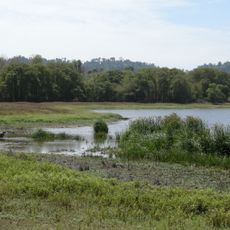
Cát Tiên National Park
22.6 km
Cát Tiên archaeological site
11.2 km
Rock with Buddha Statue
29.9 km
Monument
13.1 km
Lieng Djiran
11.2 km
Bàu Sấu Nam Cát Tiên
2.3 km
Crocodile Lake
2.3 km
Uncle Dong Tree
11 km
Buddha on the Boulder
30 km
Đá Ba Chồng
29.9 km
The Giant Ancient Tung
4.4 km
Khu du lịch Ma Đa Guôi
27.9 km
Hồ đạ tẻh
24.8 km
Demo
38.2 km
B'nöm Lu Mu
36.5 km
Đồng Nai Biosphere reserve
10.3 km
Da Huoai
25.3 km
Ben Cu
11.7 km
Scenic viewpoint
12.9 km
Trung ương Cục miền Nam
29.9 km
Scenic viewpoint
9.4 km
Monument
18.5 km
Tượng Ðài Chiến Thắng La Ngà
33.7 km
House
24.5 km
Scenic viewpoint
10.7 km
Wayside cross
26.2 km
Thác Đạ K'La
24.9 km
Dung Waterfall (Thac Dung)
37.4 kmVisited this place? Tap the stars to rate it and share your experience / photos with the community! Try now! You can cancel it anytime.
Discover hidden gems everywhere you go!
From secret cafés to breathtaking viewpoints, skip the crowded tourist spots and find places that match your style. Our app makes it easy with voice search, smart filtering, route optimization, and insider tips from travelers worldwide. Download now for the complete mobile experience.

A unique approach to discovering new places❞
— Le Figaro
All the places worth exploring❞
— France Info
A tailor-made excursion in just a few clicks❞
— 20 Minutes