Enable Location

We need your location to show you interesting places around you

Discover nearby places

Find interesting locations and hidden gems around you

Precise directions

Get accurate directions and distances to places

Your location is never shared with other users. It's only used when you tap the location button.

Cát Tiên National Park

Log in to your account

Start exploring — it's free

Trusted by 61,404 travelers worldwide

Continue with Google
Continue with Apple
or

We will send you a code to connect

By continuing, you accept our Terms and Conditions and our Privacy Policy

Check your inbox

We've sent a pincode in your inbox. Please enter the code below.

Cát Tiên National Park, National park in Đồng Nai province, Vietnam

Description

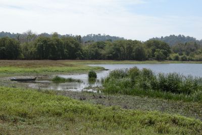
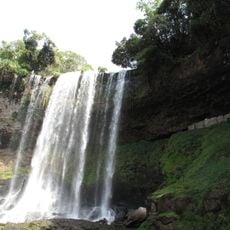
Cát Tiên National Park is a protected area in Đồng Nai province in southern Vietnam, covering tropical lowland forest, bamboo stands, wetlands, and grasslands that flood during the rainy months. The reserve spreads over roughly 720 square kilometers and contains several rivers plus a network of trails through dense vegetation and open clearings.

History

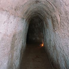
The protected area formed in 1978 when three smaller reserves named Nam Cat Tien, Tay Cat Tien, and Cat Loc joined together. Archaeologists discovered remains of a Hindu civilization near the western boundary that existed here between the 4th and 9th centuries.

Culture

The forests and wetlands still carry names from the Ma and Stieng languages, spoken by communities who lived in this landscape for centuries. At Talai village today, descendants of these groups maintain their connection to the region through ceremonies and traditional crafts that travelers can witness during organized encounters.

Practical

The journey usually begins from Ho Chi Minh City along a route of about 150 kilometers heading north through rural countryside. Local guides lead walks on forest trails and assist with spotting wildlife during early morning and late afternoon hours when animals are most active.

Did you know?

Near the western boundary, excavators found temple remains and stone sculptures from a Hindu culture that existed here between the 4th and 9th centuries. This archaeological site goes unnoticed by most visitors, even though it offers insight into an ancient trade network linking India and Southeast Asia.

Location
Inception
1978
Elevation above the sea
159 m
Part of
Southern Vietnam
GPS coordinates
11.34722,107.15139
Latest update
January 28, 2026 08:13

AroundUs brings together thousands of curated places, local tips, and hidden gems, enriched daily by 60,000 contributors worldwide. Discover all places nearby (Đồng Nai).

« Cát Tiên National Park - National park in Đồng Nai province, Vietnam » is provided by Around Us (aroundus.com). Images and texts are derived from Wikimedia project under a Creative Commons license. You are allowed to copy, distribute, and modify copies of this page, under the conditions set by the license, as long as this note is clearly visible.

Discover hidden gems everywhere you go!

From secret cafés to breathtaking viewpoints, skip the crowded tourist spots and find places that match your style. Our app makes it easy with voice search, smart filtering, route optimization, and insider tips from travelers worldwide. Download now for the complete mobile experience.

Around Us App Screenshot

A unique approach to discovering new places

Le Figaro

All the places worth exploring

France Info

A tailor-made excursion in just a few clicks

20 Minutes

Around Us
Travel Guide & Maps
Download

Send to your phone

QR Code
1

Open the camera app on your mobile.

2

Point at the QR code with your camera. A notification will appear.

3

Tap the notification to open the link.