Großflächiges LSG zwischen Epe, Heek, Ahaus, ehemaliges Landschaftsschutzgebiet in Nordrhein-Westfalen
Location: Borken
Inception: 1975
GPS coordinates: 52.07920,7.08120
Latest update: June 14, 2024 18:19
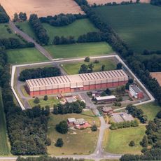
Nuclear waste storage Ahaus
1.8 km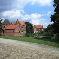
Haus Egelborg
4.8 km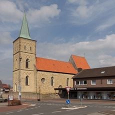
St. Ludger (Heek)
4.7 km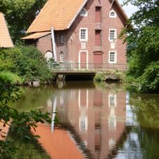
Düstermühle
934 m
Dinkelniederung
4.2 km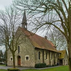
St. Antonius Abt
4 km
LSG Dinkelniederung Heek-Legden
1.2 km
LSG Wehr und Beikelort
1.7 km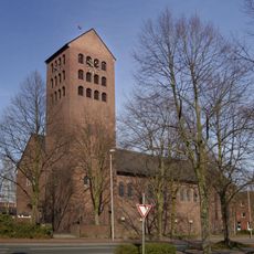
St. Josef
4.8 km
LSG Averbeck und Gemen
3.8 km
LSG Ammeln/Broecke/Loh
4.8 km
LSG-Averbeck-Gemen
3.2 km
LSG Suedahler Mark
3.9 km
Steinkuhle
4.5 km
Oldemölls Venneken
2.6 km
Wayside shrine
3.5 km
Regina Katz
4.7 km
Alfred Katz
4.7 km
Ernst Katz
4.7 km
Julia Gumpert
4.7 km
Kalvarienberg
4.8 km
Juliane 'Julie' Katz
4.7 km
Wayside shrine
4.7 km
Dinkelaue mit Oldemölls Venneken
4.2 km
Hl. Nepomuk
4.9 km
Alfred Löwenstein
4.9 km
Löwenstein
4.9 km
Hedwig Löwenstein
4.9 kmReviews
Visited this place? Tap the stars to rate it and share your experience / photos with the community! Try now! You can cancel it anytime.
Discover hidden gems everywhere you go!
From secret cafés to breathtaking viewpoints, skip the crowded tourist spots and find places that match your style. Our app makes it easy with voice search, smart filtering, route optimization, and insider tips from travelers worldwide. Download now for the complete mobile experience.

A unique approach to discovering new places❞
— Le Figaro
All the places worth exploring❞
— France Info
A tailor-made excursion in just a few clicks❞
— 20 Minutes