Enable Location

We need your location to show you interesting places around you

Discover nearby places

Find interesting locations and hidden gems around you

Precise directions

Get accurate directions and distances to places

Your location is never shared with other users. It's only used when you tap the location button.

Wetherby Ings

Log in to your account

Start exploring — it's free

Trusted by 61,492 travelers worldwide

Continue with Google
Continue with Apple
or

We will send you a code to connect

By continuing, you accept our Terms and Conditions and our Privacy Policy

Check your inbox

We've sent a pincode in your inbox. Please enter the code below.

Wetherby Ings

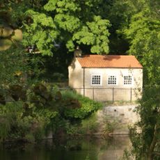
Wetherby Ings, Water meadow in Wetherby, United Kingdom.

Description

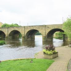
Wetherby Ings is a water meadow running along both banks of the River Wharfe with open grasslands and sports fields spread across the site. A footbridge connects the north and south sections, allowing visitors to move easily between the different areas.

History

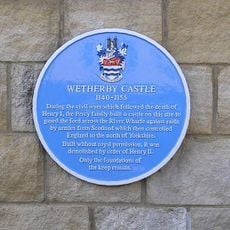
The meadows developed as traditional grassland that naturally manages flood risk along the River Wharfe through overflow zones. This long-standing land use reflects how the river and surrounding terrain have worked together for generations.

Culture

Local sports clubs like Wetherby Athletic AFC and Wetherby Bulldogs RLFC use these grounds for regular training and matches, making them social hubs for the community. The facilities on the south bank bring people together on match days throughout the season.

Practical

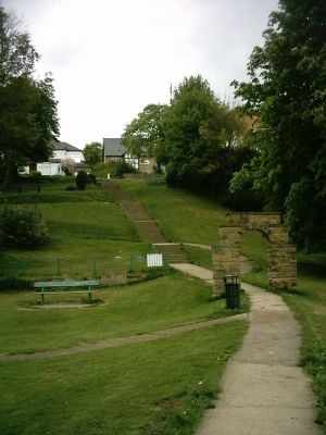
The site is accessible from Wetherby town center via marked pathways, with King George's Field offering a playground and football pitch for visitors. During wet weather, paths can become muddy, so waterproof footwear is a sensible choice.

Did you know?

After heavy rainfall, the River Wharfe naturally spills into the meadows, creating temporary wetland habitats that attract rare water birds and insects. This seasonal flooding is a hidden benefit that many visitors miss when the site appears quiet and dry.

GPS coordinates
53.92600,-1.39100
Latest update
December 14, 2025 12:26

AroundUs brings together thousands of curated places, local tips, and hidden gems, enriched daily by 60,000 contributors worldwide. Discover all places nearby (United Kingdom).

Around this place
Wetherby Bridge
United Kingdom

Wetherby Bridge

333 m
St James' Parish Church, Wetherby
United Kingdom

St James' Parish Church, Wetherby

537 m
Wetherby Town Hall
United Kingdom

Wetherby Town Hall

389 m
St Joseph's Church, Wetherby
United Kingdom

St Joseph's Church, Wetherby

442 m
Wetherby Wesleyan Methodist Church
United Kingdom

Wetherby Wesleyan Methodist Church

434 m
Wetherby Bridge (Over River Wharfe) With Attached War Memorial
United Kingdom

Wetherby Bridge (Over River Wharfe) With Attached War Memorial

327 m
The Brunswick
United Kingdom

The Brunswick

421 m
Bar Three
United Kingdom

Bar Three

329 m
Wetherby Library and Tourist Information
United Kingdom

Wetherby Library and Tourist Information

374 m
Barleyfield Road Bridge
United Kingdom

Barleyfield Road Bridge

1 km
Sant Angelo
United Kingdom

Sant Angelo

449 m
Railway Engine Shed Approximately 200 Metres North East Of Junction With Deighton Road
United Kingdom

Railway Engine Shed Approximately 200 Metres North East Of Junction With Deighton Road

1 km
Swan And Talbot
United Kingdom

Swan And Talbot

546 m
6 And 8, Scott Lane
United Kingdom

6 And 8, Scott Lane

305 m
41, 43, 43A And 45, High Street
United Kingdom

41, 43, 43A And 45, High Street

422 m
Milepost Approximately 120 Metres To North East Of Junction With Audby Lane
United Kingdom

Milepost Approximately 120 Metres To North East Of Junction With Audby Lane

1.3 km
Wetherby Castle
United Kingdom

Wetherby Castle

218 m
Wetherby House
United Kingdom

Wetherby House

316 m
Milepost Approximately 220 Metres North Of Wetherby Lodge
United Kingdom

Milepost Approximately 220 Metres North Of Wetherby Lodge

1.7 km
Brunswick Yard (Premises Of Wetherby Workshops And C And S Racing)
United Kingdom

Brunswick Yard (Premises Of Wetherby Workshops And C And S Racing)

448 m
Bath House To South West Of Wharfedale Lawn
United Kingdom

Bath House To South West Of Wharfedale Lawn

310 m
19 And 21, Market Place
United Kingdom

19 And 21, Market Place

336 m
The Manor House
United Kingdom

The Manor House

517 m
6, Cross Street
United Kingdom

6, Cross Street

387 m
4, Cross Street
United Kingdom

4, Cross Street

391 m
Front Range Of Farm Buildings At Micklethwaite Farm
United Kingdom

Front Range Of Farm Buildings At Micklethwaite Farm

319 m
1, 3 And 5, Boston Road
United Kingdom

1, 3 And 5, Boston Road

368 m
Milestone, a third of mile S of TI jct with A58
United Kingdom

Milestone, a third of mile S of TI jct with A58

904 m
Show the full map
« Wetherby Ings - Water meadow in Wetherby, United Kingdom » is provided by Around Us (aroundus.com). Images and texts are derived from Wikimedia project under a Creative Commons license. You are allowed to copy, distribute, and modify copies of this page, under the conditions set by the license, as long as this note is clearly visible.

Discover hidden gems everywhere you go!

From secret cafés to breathtaking viewpoints, skip the crowded tourist spots and find places that match your style. Our app makes it easy with voice search, smart filtering, route optimization, and insider tips from travelers worldwide. Download now for the complete mobile experience.

Around Us App Screenshot

A unique approach to discovering new places

Le Figaro

All the places worth exploring

France Info

A tailor-made excursion in just a few clicks

20 Minutes

Around Us
Travel Guide & Maps
Download

Send to your phone

QR Code
1

Open the camera app on your mobile.

2

Point at the QR code with your camera. A notification will appear.

3

Tap the notification to open the link.