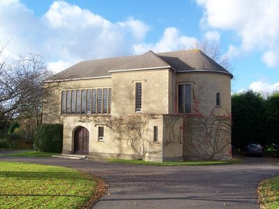
St Teresa of Avila Church, Chiddingfold, Roman Catholic church in Chiddingfold, England
St Teresa of Avila Church is a Catholic place of worship in Chiddingfold with a stone cruciform design located where Petworth and Woodside Roads meet. Inside, a central aisle runs through the nave and leads toward a semi-circular sanctuary, with a slate roof topping the entire structure.
Construction of this church began in 1959 after priests from nearby Barrow Hills School had gathered worshippers in a small village building for several years. The new building marked a transition from temporary to permanent worship space for the local Catholic community.
The church operates within the Diocese of Arundel and Brighton, sharing parish responsibilities with Our Lady of Lourdes Church in Haslemere and St Anselm Church in Hindhead.
The building sits next to Chiddingfold Cricket Club green, making it easy to locate along the main roads. Services take place regularly throughout the week, so checking ahead helps visitors plan their visit around active times.
Architect Henry Bingham Towner designed this building to flow seamlessly from the nave into the transepts without visible structural barriers dividing the space. This continuous interior layout from the 1950s remains an unusual choice for a Catholic church of its era.
The community of curious travelers
AroundUs brings together thousands of curated places, local tips, and hidden gems, enriched daily by 60,000 contributors worldwide.