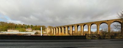
Denby Dale Railway Viaduct, Railway viaduct in Denby Dale, England.
Denby Dale Railway Viaduct is a stone bridge built to carry trains across the Dearne Valley, constructed with 21 stone arches supporting the railway line above. The arches span roughly 12 meters each, and the entire structure rises about 34 meters (112 feet) from the valley floor below.
The original wooden bridge was built in 1847 to carry the new railway line across the valley but suffered serious damage from bad weather conditions. In 1880, engineers replaced it with the current stone structure as a more permanent and reliable solution.
The structure symbolizes Victorian industrial expansion across Yorkshire and demonstrates how railways connected manufacturing communities that would otherwise remain separated. Locals today see it as a monument to the engineering ambition that transformed their region.
The viaduct is best viewed from below, where walking paths run underneath the arches and offer clear views of the stone structure. The ground beneath the bridge can be damp and slippery after rain, so sturdy footwear is advisable when exploring the area.
Building this viaduct was financially challenging for the local contractor Naylor Brothers, who suffered losses during construction despite completing the project. What emerged from these difficulties was a remarkably durable structure that has carried trains safely for well over a century.
The community of curious travelers
AroundUs brings together thousands of curated places, local tips, and hidden gems, enriched daily by 60,000 contributors worldwide.