
Barn At Smewins, Approximately 30 Metres North East Of Nos 1 And 2
Barn At Smewins, Approximately 30 Metres North East Of Nos 1 And 2, barn in Shottesbrooke, Windsor and Maidenhead, Berkshire, UK
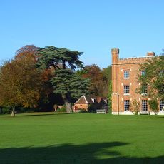
Shottesbrooke Park
1.3 km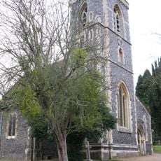
Church of St Mary
1.6 km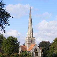
Church of St John the Baptist, Shottesbrooke
1.1 km
Kitchen Garden And Orchard Walls With Attached Orangery And Outbuildings South Of Shottesbrooke Park
991 m
29 Shottesbrooke
633 m
Smewins Cottage
45 m
Burycourt Farmhouse
1.5 km
Bryher Cottage And The Old Barn Cottage
1.6 km
Crockfords Cottage
1.5 km
Implement Shed And Adjoining Cottage, Approximately 120 Metres North West Of Beenham's Farmhouse On Other Side Of Road
1.2 km
Ivy Cottage
1.5 km
28 and 28A Shottesbrooke
684 m
Fountain In The Garden Of The Old Cottage, Approximately 30 Metres South Of Church Of St John The Baptist
1.1 km
Moated site at Smewin's Farm
52 m
Former Cartshed Approximately 80 Metres North West Of Beenham's Farmhouse On Other Side Of Road
1.3 km
Group Of 5 Gravestones, Approximately 5 Metres From South Transept Of Church Of St John The Baptist
1.1 km
Littlefield Farmhouse
1.3 km
Group Of 3 Gravestones, Approximately 2 Metres East Of South Transept Of Church Of St John The Baptist
1.1 km
Barn At Smewins, Approximately 40 Metres South East Of Nos 1 And 2 (Smewins Cottages)
33 m
Beenham's Farmhouse
1.3 km
Boundary Wall On East And Part Of North And South Sides Of Beenham's Farmyard
1.2 km
Barn Approximately 70 Metres East South East Of Beenham's Farmhouse
1.3 km
Stables Approximately 100 Metres East South East Of Beenham's Farmhouse
1.2 km
Barn Approximately 45 Metres North East Of Beenham's Farmhouse
1.3 km
Ice House Appr0Ximately 20 Metres North West Of Shottesbrooke Park
1.4 km
Headstone, Approximately 10 Metres South West Of South Aisle Of Church Of St Mary
1.5 km
Former Cowhouse And Adjoining Wall Approximately 90 Metres North West Of Beenham's Farmhouse On Other Side Of Road
1.2 km
Stocks And Whipping Post
1.6 kmReviews
Visited this place? Tap the stars to rate it and share your experience / photos with the community! Try now! You can cancel it anytime.
Discover hidden gems everywhere you go!
From secret cafés to breathtaking viewpoints, skip the crowded tourist spots and find places that match your style. Our app makes it easy with voice search, smart filtering, route optimization, and insider tips from travelers worldwide. Download now for the complete mobile experience.

A unique approach to discovering new places❞
— Le Figaro
All the places worth exploring❞
— France Info
A tailor-made excursion in just a few clicks❞
— 20 Minutes