Chantry Mill, mill in Storrington and Sullington, Horsham, West Sussex, UK
Location: Storrington and Sullington
GPS coordinates: 50.91355,-0.44766
Latest update: November 19, 2025 19:25
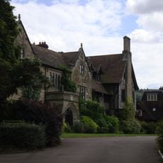
The Abbey, Storrington
642 m
31 and 33, Church Street
630 m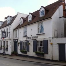
The Old Market Rooms The White Horse Hotel
643 m
Brook Cottage
503 m
The Old House Cottage
374 m
Byne
472 m
Mulberry House
661 m
1 and 3, School Hill
558 m
10-14, Brewers Yard
657 m
Animal Fare The Old Forge
666 m
18 20 And 22, High Street
597 m
Pair of bowl barrows 280m SE of Trinity Methodist Church, forming part of a round barrow cemetery on Sullington Warren
573 m
Brook House
490 m
No 41 And The Garden Wall And Gate Piers To South East
661 m
9, High Street
613 m
7 And 9, West Street
656 m
The Palace
655 m
Emmas Market And Old Rosemary
635 m
Gateway At The North West Corner Of The Kitchen Garden Wall Of St Joseph's Dominican Convent At The Corner Of Brown's Lane And Church Street
634 m
Georgian House Including Front Garden Railing To East
657 m
Bowl barrow 200m SE of Trinity Methodist Church, forming part of a round barrow cemetery on Sullington Warren
630 m
2, School Hill
536 m
11, West Street
655 m
Abbey Convent
641 m
2 And 4, East Brook
519 m
Orchard Dale
654 m
16 And 17, Brewers Yard
638 m
Nifty Art Gallery
532 mReviews
Visited this place? Tap the stars to rate it and share your experience / photos with the community! Try now! You can cancel it anytime.
Discover hidden gems everywhere you go!
From secret cafés to breathtaking viewpoints, skip the crowded tourist spots and find places that match your style. Our app makes it easy with voice search, smart filtering, route optimization, and insider tips from travelers worldwide. Download now for the complete mobile experience.

A unique approach to discovering new places❞
— Le Figaro
All the places worth exploring❞
— France Info
A tailor-made excursion in just a few clicks❞
— 20 Minutes