The Vicarage, clergy house in East Malling and Larkfield, Tonbridge and Malling, Kent, UK
Location: East Malling and Larkfield
GPS coordinates: 51.28697,0.43896
Latest update: November 23, 2025 08:30

Church of St James
131 m
4 and 6, Church Walk
65 m
Andrewes Tomb 4 Yards North East Of Malling Church
129 m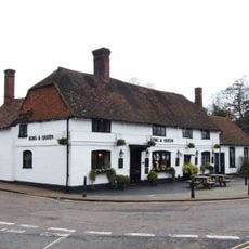
The King And Queen Public House
87 m
Tamarisk Cottage
207 m
Holly Cottage Raven Cottage
191 m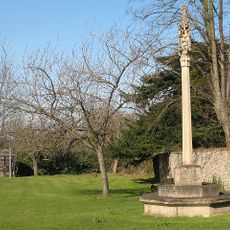
East Malling War Memorial
82 m
24 And 26, High Street
29 m
Kinross Cottage
187 m
11, Mill Street
83 m
10-16, High Street
30 m
Court Lodge
109 m
Thornhill Tomb 15 Yards West North West Of East Malling
109 m
Part of an Iron Age enclosure and a minor Roman villa 128m SSE of the Church of St James
174 m
45, High Street
73 m
The Forge House
53 m
Ingleside
54 m
1-5, Mill Street
61 m
Ivy House Farmhouse
337 m
Wall To North East Of The Limes
238 m
6, The Rocks Road
150 m
69-75, Mill Street
365 m
Barn 30 Yards West Of Ivy House Farmhouse
336 m
Andrewes Tomb 10 Yards North Of East Malling Church
134 m
Andrewes Tomb 6 Yards North Of East Malling Church
131 m
The Limes
252 m
Malting's Restaurant
61 m
Andrewes Tomb 8 Yards North Of East Malling Church
132 mReviews
Visited this place? Tap the stars to rate it and share your experience / photos with the community! Try now! You can cancel it anytime.
Discover hidden gems everywhere you go!
From secret cafés to breathtaking viewpoints, skip the crowded tourist spots and find places that match your style. Our app makes it easy with voice search, smart filtering, route optimization, and insider tips from travelers worldwide. Download now for the complete mobile experience.

A unique approach to discovering new places❞
— Le Figaro
All the places worth exploring❞
— France Info
A tailor-made excursion in just a few clicks❞
— 20 Minutes