Field Head Farmhouse, farmhouse in Shotley Low Quarter, Northumberland, UK
Location: Shotley Low Quarter
GPS coordinates: 54.86513,-1.88116
Latest update: November 14, 2025 13:46
Shotley Hall
1.2 km
Burn House, And Burn House Cottage
804 m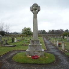
Shotley Low Quarter War Memorial
1.4 km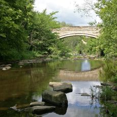
Shotley Bridge
1.4 km
King's Head Hotel
1.5 km
Outbuilding South Of Messenger House
1.5 km
Gate Piers In Front Of St Cuthbert's School
1.6 km
St Cuthbert's School
1.6 km
St Cuthbert's Vicarage
1.6 km
Church of St Cuthbert
1.6 km
Walls In Front Of Numbers 22 To 24
1.4 km
Grove House and Azalea Court
1 km
Garden Pond West Of Grove House
986 m
Lloyd's Bank
1.6 km
Garden Ornament 6 Metres East Of South-East Corner Of Shotley Hall
1.2 km
Shotley Hall Stable Block And Attached Wall To South-West
1.2 km
Lodge, Piers, Gate And Railings To Grove House
1 km
Piers And Wall To Garden To Garden Of Grove House
999 m
Messenger House
1.5 km
Church of St John
1.4 km
Gate Piers To Shotley Hall, With Attached Forecourt Walls
1.2 km
Walls And Piers In Front Of St Cuthbert's Vicarage
1.6 km
22, 23 and 24 Cutlers' Hall Road
1.4 km
Orchard House
1.4 km
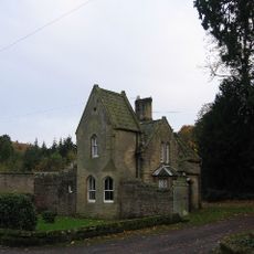
Gate Lodge To Shotley Hall
1.2 km
Farmbuildings North And East Of High Waskerley Farmhouse
1.3 km
High Waskerley Farmhouse
1.3 km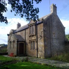
Forge Cottage
856 mReviews
Visited this place? Tap the stars to rate it and share your experience / photos with the community! Try now! You can cancel it anytime.
Discover hidden gems everywhere you go!
From secret cafés to breathtaking viewpoints, skip the crowded tourist spots and find places that match your style. Our app makes it easy with voice search, smart filtering, route optimization, and insider tips from travelers worldwide. Download now for the complete mobile experience.

A unique approach to discovering new places❞
— Le Figaro
All the places worth exploring❞
— France Info
A tailor-made excursion in just a few clicks❞
— 20 Minutes