Enable Location

We need your location to show you interesting places around you

Discover nearby places

Find interesting locations and hidden gems around you

Precise directions

Get accurate directions and distances to places

Your location is never shared with other users. It's only used when you tap the location button.

Wallington Town Hall

Log in to your account

Start exploring — it's free

Trusted by 62,983 travelers worldwide

Continue with Google
Continue with Apple
or

We will send you a code to connect

By continuing, you accept our Terms and Conditions and our Privacy Policy

Check your inbox

We've sent a pincode in your inbox. Please enter the code below.

Wallington Town Hall
Discussion Reviews 1 Photos
1.4k Popularity

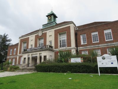
Wallington Town Hall, Grade II listed municipal building in Wallington, London Borough of Sutton, England

Wallington Town Hall is a Grade II listed municipal building in London Borough of Sutton featuring eleven bays with a central section containing a porch with fluted pilasters and a first-floor balcony on Woodcote Road. The structure houses various spaces within its organized facade.

The foundation stone was laid in May 1934, and Sir Richard Meller, Member of Parliament for Mitcham, inaugurated the building in September 1934. It served as a courthouse until 1999 before transitioning to educational use.

The interior features a double-height council chamber decorated with walnut paneling and a black and white marble staircase in art deco style. These elements were designed to convey importance and formality.

The building now operates as part of Sutton College, providing educational facilities to the community. Access is arranged according to college schedules and academic activities.

The roof features a copper-clad clock tower with a weather vane, and the clock mechanism was manufactured by Gillett and Johnston of Croydon. This local craftsmanship reflects the period of its creation.

The community of curious travelers

AroundUs brings together thousands of curated places, local tips, and hidden gems, enriched daily by 60,000 contributors worldwide.

Start exploring
Inception
1935
GPS coordinates
51.35790,-0.15010
Latest update
December 14, 2025 16:44
Around this place
Charles Cryer Theatre
United Kingdom

Charles Cryer Theatre

1.1 km
Carshalton Public Library
United Kingdom

Carshalton Public Library

1.1 km
Church of St Michael and All Angels
United Kingdom

Church of St Michael and All Angels

629 m
Church of the Holy Trinity
United Kingdom

Church of the Holy Trinity

760 m
Grotto In Carshalton Park
United Kingdom

Grotto In Carshalton Park

732 m
The Woodman
United Kingdom

The Woodman

1.2 km
Dukes Head Public House
United Kingdom

Dukes Head Public House

1 km
Beddington and Wallington War Memorial
United Kingdom

Beddington and Wallington War Memorial

1.1 km
5 And 7, High Street
United Kingdom

5 And 7, High Street

1.2 km
3-9, Wrights Row
United Kingdom

3-9, Wrights Row

964 m
Piers Wall And Railings To The Original Parkfields
United Kingdom

Piers Wall And Railings To The Original Parkfields

1.2 km
Westcroft
United Kingdom

Westcroft

1.1 km
Number 19 Sewer Ventilation Column in Rotherfield Road (east side) at junction with Talbot Road
United Kingdom

Number 19 Sewer Ventilation Column in Rotherfield Road (east side) at junction with Talbot Road

890 m
120, Woodcote Road
United Kingdom

120, Woodcote Road

53 m
Wall To Rear Of Number 6 Connecting Numbers 4 And 6
United Kingdom

Wall To Rear Of Number 6 Connecting Numbers 4 And 6

1.2 km
Pier Incorporating Boundary Stone And Wall To Rear
United Kingdom

Pier Incorporating Boundary Stone And Wall To Rear

1.2 km
Number 10 Sewer Ventilation Column at the junction of Grovesnor Road and Glebe Road
United Kingdom

Number 10 Sewer Ventilation Column at the junction of Grovesnor Road and Glebe Road

999 m
Bramblehaw End
United Kingdom

Bramblehaw End

1.2 km
Sewer ventilation column at Cator Road
United Kingdom

Sewer ventilation column at Cator Road

1.1 km
Number 14 Sewer ventilation column on Lavender Road
United Kingdom

Number 14 Sewer ventilation column on Lavender Road

953 m
Number 3 Sewer Ventilation Column on the railway bridge on Boundary Road
United Kingdom

Number 3 Sewer Ventilation Column on the railway bridge on Boundary Road

417 m
4, High Street
United Kingdom

4, High Street

1.1 km
32, Manor Road
United Kingdom

32, Manor Road

894 m
Premises Of South East Electricity Board
United Kingdom

Premises Of South East Electricity Board

1.1 km
38, 40 And 40A, Manor Road
United Kingdom

38, 40 And 40A, Manor Road

851 m
16-20, High Street
United Kingdom

16-20, High Street

1.1 km
6, The Square
United Kingdom

6, The Square

1.1 km
36, Manor Road
United Kingdom

36, Manor Road

870 m
Show the full map
Reviews
Share your experience

No review yet

Discussions
Start a discussion...

No discussion yet

« Wallington Town Hall - Grade II listed municipal building in Wallington, London Borough of Sutton, England » is provided by Around Us (aroundus.com). Images and texts are derived from Wikimedia project under a Creative Commons license. You are allowed to copy, distribute, and modify copies of this page, under the conditions set by the license, as long as this note is clearly visible.

Discover hidden gems everywhere you go!

From secret cafés to breathtaking viewpoints, skip the crowded tourist spots and find places that match your style. Our app makes it easy with voice search, smart filtering, route optimization, and insider tips from travelers worldwide. Download now for the complete mobile experience.

Around Us App Screenshot

A unique approach to discovering new places

Le Figaro

All the places worth exploring

France Info

A tailor-made excursion in just a few clicks

20 Minutes

Around Us
Travel Guide & Maps
Download

Send to your phone

QR Code
1

Open the camera app on your mobile.

2

Point at the QR code with your camera. A notification will appear.

3

Tap the notification to open the link.