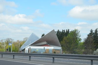
Markham Moor Scorer Building, Grade II listed building in West Drayton, England.
The Markham Moor Scorer Building is a roadside service structure with four concrete columns and a curved roof design. The roof height varies between approximately 5 and 37 feet, creating a distinctive silhouette across the entire composition.
This structure was built in 1960 by architect Sam Scorer and engineer Dr. Hajnal-Kónyi as a petrol station for National Benzole. It became an example of modern commercial design serving motorway traffic of that era.
The building shows how architects of that era experimented boldly with new materials and forms for roadside service buildings. You can still see today how the slender concrete structure conveys the idea of modern, lightweight design.
The building is located directly along the A638 near Retford and is easy to spot from the main road. You can view the structure from outside as it operates as a service facility for travelers passing through.
The roof is made from a thin concrete shell about 75 millimeters thick, engineered to appear to float weightlessly above the supporting columns. This technical solution was experimental when created and shows the boldness of the design approach at that time.
Location: West Drayton
GPS coordinates: 53.25688,-0.92770
Latest update: December 12, 2025 09:02
Milton Mausoleum
854 m
Church of Our Lady of Egmanton
5.3 km
Holy Trinity Church, Kirton
5.2 km
All Saints' Church, West Markham
1.3 km
St Nicholas' Church, Tuxford
3.5 km
St Giles' Church, Elkesley
3.2 km
St Edmund's Church, Walesby
4.4 km
Our Lady and St Peter's Church, Bothamsall
4.1 km
Church of St. John the Baptist, East Markham
2.9 km
All Saints' Church, Eaton
4.2 km
St Peter's Church, Gamston
2.3 km
St. Nicholas' Church, Askham
2.6 km
St. Peter's Church, Headon-cum-Upton
4.6 km
St Paul's Church, West Drayton
1 km
Church of St James
2.7 km
Duke William Public House
2.6 km
Tuxford War Memorial
3.5 km
Rebel Stone
4.7 km
Tuxford Library
3.5 km
East Markham War Memorial
2.3 km
Lock Up
3.6 km
Milestone, 40 Metres North West Of Jockey House
4.1 km
Milestone 50 Metres East Of Meadow View
158 m
Egmanton War Memorial
5.3 km
Sign Post
3.5 km
Range of farmbuildings at Portland Farm
3.2 km
Sundial 5 Metres South Of South Transept Of Church Of St Mary
5.3 km
Milestone, Old London Road, Milestone Cottage, nr Morton Grange
4.9 kmVisited this place? Tap the stars to rate it and share your experience / photos with the community! Try now! You can cancel it anytime.
Discover hidden gems everywhere you go!
From secret cafés to breathtaking viewpoints, skip the crowded tourist spots and find places that match your style. Our app makes it easy with voice search, smart filtering, route optimization, and insider tips from travelers worldwide. Download now for the complete mobile experience.
A unique approach to discovering new places❞
— Le Figaro
All the places worth exploring❞
— France Info
A tailor-made excursion in just a few clicks❞
— 20 Minutes