
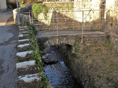
Footbridge over brook at West entrance to churchyard of Church of St Illtud
Footbridge over brook at West entrance to churchyard of Church of St Illtud, Grade II listed building in Vale of Glamorgan. Outside the churchyard wall and directly to the west of the Church of St Illtud.
Location: Llantwit Major
Elevation above the sea: 37.4 m
GPS coordinates: 51.40788,-3.48830
Latest update: April 13, 2025 23:24

St Illtyd's Church, Llantwit Major
44 m
Llantwit Major Town Hall
157 m
Tudor Tavern P.H.
138 m
Bethel Baptist Chapel
264 m
The Old Police Station
55 m
Llantwit Major War Memorial
131 m
Old White Hart P.H.
120 m
Old Swan Inn
168 m
Old Place (or Llantwit Major Castle)
324 m
Cross in Churchyard of Church of St. Illtud
44 m
Tabernacle Calvinistic Methodist Chapel
192 m
Court House
300 m
West Farmhouse
204 m
Telephone Call-Box outside Old White Hart P.H.
133 m
Plymouth House
135 m
Outhouse at Sunny Bank
414 m
Chantry House
53 m
Corner House
343 m
Swimbridge Farmhouse with attached garden walls
202 m
Llantwit Major Dovecote
102 m
The Old School, including attached walling
114 m
Former Chantry Priest's House
42 m
The Old House
366 m
Quaintways, with attached garden wall
279 m
The Gatehouse (porter's Room)
45 m
Fonmon Cottage
277 m
To-hesg including attached garden walls
398 m
Pear Tree Cottage with attached wall and mounting block
346 mVisited this place? Tap the stars to rate it and share your experience / photos with the community! Try now! You can cancel it anytime.
Discover hidden gems everywhere you go!
From secret cafés to breathtaking viewpoints, skip the crowded tourist spots and find places that match your style. Our app makes it easy with voice search, smart filtering, route optimization, and insider tips from travelers worldwide. Download now for the complete mobile experience.

A unique approach to discovering new places❞
— Le Figaro
All the places worth exploring❞
— France Info
A tailor-made excursion in just a few clicks❞
— 20 Minutes