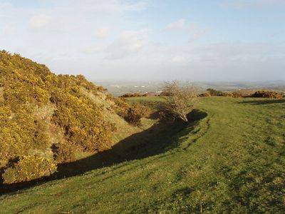
Warbstow Bury, Iron Age hillfort in Cornwall, United Kingdom.
Warbstow Bury is an Iron Age fortification perched on elevated terrain in Cornwall, surrounded by two concentric earthen ramparts with openings facing northwest and southeast. The site encompasses a broad area with a mound at its center.
This defensive post was constructed during the Iron Age and served a crucial defensive purpose in the region. The site saw later reuse and modifications as its original function was superseded.
The site features in local folklore about a giant who once dwelled here, and these stories continue to shape how people understand and talk about the place today.
The site is accessible throughout the year and easy to explore on foot at your own pace. Sturdy footwear is recommended, especially after rain when the ground may become slippery.
The center of the fortification holds a medieval rabbit warren that was long overlooked by earlier researchers. This secondary use from the Middle Ages contradicts earlier assumptions about the mound's purpose.
GPS coordinates: 50.68944,-4.54750
Latest update: December 14, 2025 12:23
Penpol
6.7 km
Penhallam
6.9 km
St James' Church, Jacobstow
5 km
Church of St Denis, Otterham
3.3 km
St Werburgh's Church, Warbstow
634 m
Church of St Gregory
2.8 km
St Michael and All Angels' Church, Lesnewth
7.1 km
Church of St Winwalo
3.8 km
Church of St Clether
6.5 km
Church of St David
6.2 km
Church of St Nicholas
4.6 km
Methodist Chapel
5.8 km
Sundial To South Of Church Of St David
6.2 km
Milestone 500 Metres To West Of Hallworthy
4.1 km
St Clether's Chapel and Holy Well
6.3 km
Milestone 1200 Metres To South East Of Hallworthy
3.6 km
Warbstow War Memorial
616 m
Holy Well of St Clether
6.3 km
Milestone To North East Of Napps Farm
5.6 km
Wayside cross 620m south west of Basil Farm
7 km
Holy Well 100m north east of St David's church
6.1 km
Milestone 30 Metres To North West Of Cold Northcott
4.4 km
High Hall Cross
6.3 km
Milestone Se Of Pendragon House
6.9 km
Milestone To South Of Treblary Cottage
5.4 km
Guidepost To North East Of Higher Trehane Farm
6.3 km
Milestone At Sx231848
6.7 km
Davidstow War Memorial
6.2 kmVisited this place? Tap the stars to rate it and share your experience / photos with the community! Try now! You can cancel it anytime.
Discover hidden gems everywhere you go!
From secret cafés to breathtaking viewpoints, skip the crowded tourist spots and find places that match your style. Our app makes it easy with voice search, smart filtering, route optimization, and insider tips from travelers worldwide. Download now for the complete mobile experience.
A unique approach to discovering new places❞
— Le Figaro
All the places worth exploring❞
— France Info
A tailor-made excursion in just a few clicks❞
— 20 Minutes